- Alturas Municipal Airport
-
Alturas Municipal Airport 
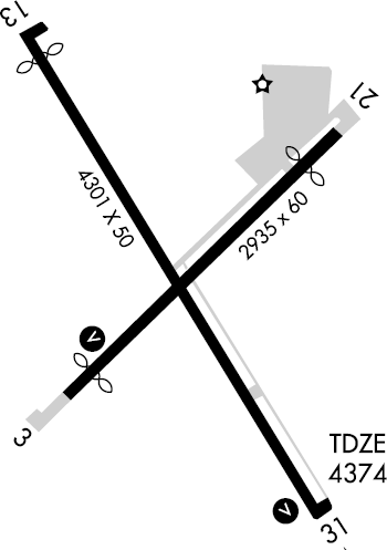
FAA runway diagram IATA: none – ICAO: KAAT – FAA LID: AAT Summary Airport type Public Owner City of Alturas Serves Alturas, California Elevation AMSL 4,378 ft / 1,334 m Coordinates 41°28′59″N 120°33′55″W / 41.48306°N 120.56528°W Runways Direction Length Surface ft m 13/31 4,300 1,311 Asphalt 3/21 3,096 944 Asphalt Statistics (2008) Aircraft operations 31,500 Source: Federal Aviation Administration[1] Alturas Municipal Airport (ICAO: KAAT, FAA LID: AAT formerly O00), is a city-owned public-use airport located one nautical mile (1.85 km) west of the central business district of Alturas, a city in Modoc County, California, United States.[1] This airport is included in the FAA's National Plan of Integrated Airport Systems for 2009–2013, which categorizes it as a general aviation facility.[2]
Although most U.S. airports use the same three-letter location identifier for the FAA and IATA, this airport is assigned AAT by the FAA but has no designation from the IATA[3] (which assigned AAT to Altay Airport in Altay, Xinjiang, China[4]).
Facilities and aircraft
Alturas Municipal Airport covers an area of 160 acres (65 ha) at an elevation of 4,378 feet (1,334 m) above mean sea level. It has two asphalt paved runways: 13/31 is 4,300 by 50 feet (1,311 x 15 m) and 3/21 is 3,096 by 60 feet (944 x 18 m). For the 12-month period ending December 31, 2008, the airport had 31,500 aircraft operations, an average of 86 per day: 95% general aviation and 5% air taxi.[1]
References
- ^ a b c FAA Airport Master Record for AAT (Form 5010 PDF). Federal Aviation Administration. Effective 11 Feb 2010.
- ^ National Plan of Integrated Airport Systems for 2009–2013: Appendix A: Part 1 (PDF, 1.33 MB). Federal Aviation Administration. Updated 15 Oct 2008.
- ^ "Alturas Municipal Airport (IATA: none, ICAO: KAAT, FAA: AAT)". Great Circle Mapper. http://www.gcmap.com/airport/KAAT. Retrieved 4 Mar 2010.
- ^ "Altay Airport, China (IATA: AAT, ICAO: ZWAT)". Aviation Safety Network. http://aviation-safety.net/database/airport/airport.php?id=AAT. Retrieved 4 Mar 2010.
External links
- Aerial image as of 25 August 1998 from USGS The National Map
- FAA Terminal Procedures for AAT, effective 20 October 2011
- Resources for this airport:
- AirNav airport information for KAAT
- FlightAware airport information and live flight tracker
- NOAA/NWS latest weather observations
- SkyVector aeronautical chart, Terminal Procedures for KAAT
Categories:- Airports in Modoc County, California
Wikimedia Foundation. 2010.