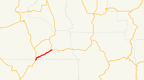
Oregon Route 293

Oregon Route 293

Oregon Route 293 marker

Oregon Route 293
Route information
Maintained by ODOT
Length: 13.52 mi (21.76 km)
Existed: 2002 – present
Major junctions
West end: US 97.svg US 97 near Willowdale
East end: OR 218.svg OR 218 in Antelope
Highway system

Oregon highways
Routes • Highways

OR 282 OR 331

Oregon Route 293 is an Oregon state highway in the north-central part of the state. It runs from Willowdale to Antelope and is known as the Antelope Highway No. 293 (see Oregon highways and routes).

Oregon Route 293 is a post-2002 number.

Despite its odd number, Oregon Route 293 is an east–west highway. It was not signed as a state highway until at least the 1990s. It is believed that Oregon Route 293 signs were posted in error, as OR 293 has always been the internal ODOT highway number. In 2002, ODOT changed its policy to allow signing of otherwise unnumbered state highways, so Oregon Route 293 officially came into existence.[original research?] Its main purpose is to connect rural Wheeler and Gilliam counties to the Bend metropolitan area. Most of Oregon Route 293 is located in Wasco County, although about a mile is in Jefferson County.

Intersections with other highways


Wikimedia Foundation. 2010.

Игры ⚽ Поможем написать курсовую

Look at other dictionaries:

  • Oregon Route 218 — Route information Maintained by …   Wikipedia

  • Oregon Route 282 — Route information Maintained by …   Wikipedia

  • Oregon Route 331 — For the former unsigned Highway 331, see Bingham Springs Highway. Oregon Route 331 Route informati …   Wikipedia

  • List of highways numbered 293 — The following highways are numbered 293: Israel Route 293 (Israel) United States Interstate 293 Alabama State Route 293 Florida Sta …   Wikipedia

  • Liste der State-, U.S.- und Interstate-Highways in Oregon — Die I 5 in der Nähe des Mount Shasta Die Liste der State, U.S. und Interstate Highways in Oregon ist eine Aufstellung von State Highways in Oregon, USA nach Art und Nummer. Das Straßennetz wird von der Highway Division der Behörde Oregon… …   Deutsch Wikipedia

  • U.S. Route 97 in Oregon — OR 4 redirects here. OR 4 may also refer to Oregon s 4th congressional district. U.S. Route 97 …   Wikipedia

  • Mt. Angel, Oregon — Nickname(s): City of Bells …   Wikipedia

  • Triangle Lake, Oregon — Triangle Lake is an unincorporated communitycite web |url=http://geonames.usgs.gov/pls/gnispublic/f?p=gnispq:3:::NO::P3 FID:1130796 |title=Feature Query Results |publisher= United States Board on Geographic Names, United States Geological Survey… …   Wikipedia

  • Boring, Oregon — Boring is an unincorporated community located in Clackamas County, Oregon, United States. It is located along Oregon Route 212, approximately eight miles south of Gresham and about the same distance from Clackamas, both suburbs of… …   Wikipedia

  • Cedar Hills, Oregon — Infobox Settlement official name = Cedar Hills, Oregon settlement type = CDP nickname = motto = imagesize = image caption = image imagesize = image caption = image mapsize = 250px map caption = Location of Cedar Hills, Oregon mapsize1 = map… …   Wikipedia

Share the article and excerpts

Direct link
Do a right-click on the link above
and select “Copy Link”