- Oregon Route 331
-
For the former unsigned Highway 331, see Bingham Springs Highway.
Oregon Route 331
Route information Maintained by ODOT Length: 4.84 mi (7.79 km) Existed: 2003 – present Major junctions South end: 
 I-84 / US 30 near Mission
North end:  OR 11 near Mission
Highway system Oregon highways
Routes • Highways←  OR 293
OR 332  →
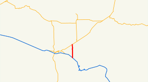
→Oregon Route 331 is an Oregon state highway running from OR 11 near Mission to Interstate 84 near Mission. OR 331 is known as the Umatilla Mission Highway No. 331 (see Oregon highways and routes). It is 4.84 miles (7.79 km) long and runs north–south, entirely within Umatilla County.
OR 331 was established in 2003 as part of Oregon's project to assign route numbers to highways that previously were not assigned.
Contents
Route description
OR 331 begins at an intersection with OR 11 about four miles (6 km) northeast of Pendleton and heads south onto the Umatilla Indian Reservation, through Mission, to an intersection with Interstate 84 and US 30, where it ends.
History
OR 331 was assigned to the Umatilla Mission Highway in 2003.
Major intersections
Milepost City Intersection 0.00 Near Mission OR 11 4.84 Near Mission Interstate 84 and US 30 References
- Oregon Department of Transportation, Descriptions of US and Oregon Routes, http://www.oregon.gov/ODOT/HWY/TRAFFIC/TEOS_Publications/PDF/Descriptions_of_US_and_Oregon_Routes.pdf, page 29.
- Oregon Department of Transportation, Umatilla Mission Highway No. 331, ftp://ftp.odot.state.or.us/tdb/trandata/maps/slchart_pdfs_1980_to_2002/Hwy331_2001.pdf
Categories:- State routes in Oregon
- Transportation in Umatilla County, Oregon


Wikimedia Foundation. 2010.