- Stoke Rochford
-
Coordinates: 52°50′09″N 0°38′20″W / 52.835864°N 0.63894175°W
Stoke Rochford 
Stoke Rochford
 Stoke Rochford shown within Lincolnshire
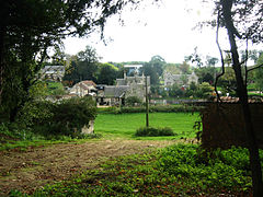
Population 142 (2001) OS grid reference SK917273 District South Kesteven Shire county Lincolnshire Region East Midlands Country England Sovereign state United Kingdom Postcode district NG33 5 Police Lincolnshire Fire Lincolnshire Ambulance East Midlands EU Parliament East Midlands UK Parliament Grantham and Stamford List of places: UK • England • Lincolnshire Stoke Rochford is a small village near Grantham in Lincolnshire.
Contents
Geography
For administration purposes, the parish is shared with Easton, which also has a country estate of its own. Stoke Rochford's church is in the parish of Easton, and so is the post office. The southern boundary of the parish follows the road, east-west, that crosses the A1 at a dangerous junction. The parish extends westwards to the Leicestershire boundary and the north edge of Saltby Airfield near the Viking Way. It follows the Lincolnshire boundary northwards for about 400 metres. North of the parish here is Wyville cum Hungerton. The parish extends to around 1 mile north of the village to North Lodge Plantation, where there is a bend westwards in the A1 as it approaches Great Ponton, which is the parish north of here. The parish extends east to the point where Ermine Street meets the East Coast Main Line. The bridge is actually just inside Great Ponton parish. Just under a mile of the line is in the parish, including the Stoke Tunnel. Just to the east is Stoke Tunnel Farm, which is actually in Bitchfield and Bassingthorpe. Just south of Stoke Tunnel is Highdyke Farm. South of here is the large Stoke Park Wood, and the eastern boundary here follows the railway line until it meets Easton parish, just south of Old Park Wood. It also borders here with Burton Coggles, just north of Sleight's Wood.
The Cringle Brook flows northwards from the village and on the opposite side of the A1 is the River Witham.
The village
Stoke Rochford is part of the civil parish[1] of Stoke Rochford and Easton.
The ecclesiastical parish is known by the same name, and is part of The Colsterworth Group in the Deanery of Beltisloe, Diocese of Lincoln. The incumbent is The Revd E J Lomax. The parish church is dedicated to Saint Andrew and Saint Mary,[2] and also serves as the parish church for Easton.
Local enterprise
There is a golf club and Welland Enterprise, who give advice to local small businesses, are based on Cringle Road. The small village has a post office. About nine miles south on the A1 is the Greetham Valley Golf Club, which offers similar packages to what the Hall and the Golf Club provide, but without the scenery.
Adjacent to the Golf course is a filling station on the A1. The associated failed cafeteria has been rebadged and The meeting place a commercial business venue.
Opposite the golf course in a former roadside cafeteria, a shop for adult products began operating in 2009. It is called Pulse and Cocktails.
People
The village's most famous current residents are Geoff Capes and Lady Sarah McCorquodale. Her husband, Neil, is on the parish council
History
The church was originally dedicated to St Mary, and village were originally South Stoke until the expansion of the park in 1843 when North Stoke was removed. The present village was laid out in 1843 to complement the architectural scheme of the new Hall, built for Christoper Turnor by William Burn.[3][4] The dedication of North Stoke church to St Andrew was transferred so that the church in Stoke Rochford has a double dedication.[5]
Hall
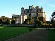
Stoke Rochford Hall, designed by William Burn and built in 1845, was gutted by fire on 25 January 2005. This is the NUT's national training centre, and a popular and picturesque venue for conferences and wedding receptions.
On 28 April 1945, a Canadian (RCAF) an Avro Lancaster crashed in the grounds of the Hall.
In December 2009, the Hall was named the Les Routiers Best Country Retreat in the UK.
Lost villages
- The Deserted medieval village of Ganthorpe, mentioned in Domesday, is now only known as a field name, Ganthrops, from the park.SK924291[6]
- North Stoke (Nortstoches) is mentioned in the Domesday Survey as a possession of Earl Morcar, claimed by the Norman baron, Drew de Beurere. It survived until the 19th century, when it was cleared in the creation of the current park.SK916284[7] The remains of a Saxon cross from the old church discovered after the demolition are now in Stoke Rochford Church.
See also
- Stoke Rochford Hall
- Easton
- Harlaxton Manor
References
- ^ Parish Council "Civil Parish Details". http://parishes.lincolnshire.gov.uk/StokeRochfordandEaston Parish Council.
- ^ "Ecclesiastical parish details". http://www.lincoln.anglican.org/search_parishes.php?14019030.
- ^ "National Monument record for the house and park". http://pastscape.english-heritage.org.uk/hob.aspx?hob_id=1129461.
- ^ "Historical details from the Hall's own web site". http://www.stokerochfordhall.co.uk/history.html.
- ^ "National Monument record for the church". http://pastscape.english-heritage.org.uk/hob.aspx?hob_id=325454.
- ^ "National Monument Record for Ganthorpe". http://www.pastscape.org.uk/hob.aspx?hob_id=325439.
- ^ "National Monument Record for North Stoke". http://www.pastscape.org.uk/hob.aspx?hob_id=325460.
External links
- Stoke Rochford Hall
- Welland Enterprise
- Golf Club
- Seniors Golf Club
- Church of St Mary and St Andrew
- The Meeting Venue
- Pulse and Cocktails
Video links
- Video View of Stoke Rochford village retrieved 18 Dec 2010
News items
Categories:- Villages in Lincolnshire
- Civil parishes in Lincolnshire
- South Kesteven
- Golf clubs and courses in England
Wikimedia Foundation. 2010.


