- Southern California Logistics Airport
Infobox Airport
name = Southern California Logistics Airport
nativename =
nativename-a =
nativename-r =
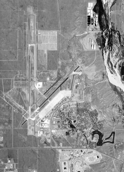
image-width =
caption = Airphoto taken 28 May 1994
IATA = VCV
ICAO = KVCV
type = Public
owner =
operator =United States Air Force
city-served = Victorville, California
location =
elevation-f = 2,885
elevation-m = 879
coordinates = Coord|34|35|51|N|117|22|59|W|type:airport
website =
metric-elev =
metric-rwy =
r1-number = 17/35
r1-length-f = 15,050
r1-length-m = 4,587
r1-surface =Asphalt /Concrete
r2-number = 3/21
r2-length-f = 9,138
r2-length-m = 2,785
r2-surface = Asphalt/Concrete
stat-year =
stat1-header =
stat1-data =
stat2-header =
stat2-data =
footnotes = :"For the military use of this facility prior to 1993, seeGeorge Air Force Base "Southern California Logistics Airport Airport codes|VCV|KVCV, also known as Victorville Airport, is a publicairport located in the city of Victorville in San Bernardino County,California , USA approximately convert|20|mi|km north of San Bernardino.Prior to its civil usage, the facility was known as George Air Force Base, (1941-1992) which was a front-line
United States Air Force base.Facilities
Southern California Logistics Airport covers 2,300 acres (9.3 km²) and has two runways:
* Runway 17/35: 15,050 x 150 ft (4,587 x 46 m), Surface: Asphalt/Concrete
* Runway 03/21: 9,138 x 150 ft (2,785 x 46 m), Surface: Asphalt/ConcreteAirport Overview
The federal government is responsible for helping the
Victor Valley recover from the closure of George Air Force Base in 1992. The conversion of the former George Air Force Base to Southern California Logistics Airport [SCLA] was designed to provide major corporations with logistics needs access to a globalintermodal logistics gateway to the Western United States. Located nearInterstate 15 in California 's Victor Valley, the 5,000 acre (20 km²) complete intermodal business complex is approximately convert|20|mi|km north ofdowntown San Bernardino , and convert|23|mi|km north ofSan Bernardino International Airport .In July
2000 the Department of Commerce awarded the Southern California Logistics Airport the designation ofForeign Trade Zone . The designation was intended to make it much easier for the Victor Valley Economic Development Authority to convince international carriers to use the airport as a base for shipping foreign products to Southern California. During that same period, the Department of Transportation approved a $4.9 million grant for the Southern California Logistics Airport to extend its main runway from convert|10050|ft|m to convert|13050|ft|m to accommodate international jet transports. The airport authority required the convert|3000|ft|m|abbr=on extension to ensure that cargo planes could depart fully-loaded in summer heat. The longer runway was also required efficient use of the facility as the main transportation hub for the 70,000 troops a year traveling to and from the Army National Training Center at Fort Irwin.The
Fiscal Year 2002 military spending bill earmarked $1.3 million to allow theU.S. Army to continue using the Southern California Logistics Airport (SCLA) to transporttroops en route to training exercises atFort Irwin . The airport has proven to be one of the most efficient and safest locations for travel to and from the Army's National Training Center for the 60,000 troops who rotate through each year. Company D of the 158th Aviation Regiment is a general support aviation company that moved in under a five-year contract the Army signed with SCLA and the city of Victorville. The unit is part of the 244th Aviation Brigade ofFort Sheridan, IL .The airport has been used for many Hollywood movies, including "
Face/Off " and "Jarhead", and was namechecked (as Victorville) in "The War of the Worlds (1953 film) ".In late 2006, SCLA became home to Air
Tanker 910 which is on contract to theCalifornia Department of Forestry (CALFIRE). Tanker 910 is the onlywide-body jet currently in-service and uses SCLA as its re-loading base for fires occurring anywhere inCalifornia .On
August 9 2007 DARPA announced that for their 2007 Autonomous Vehicle Competition both the Urban Challenge NQE and final event will take place at the urban military training facility located on the former George Air Force Base. DARPA selected the location because its network of urban roads best simulate the type of terrain American forces operate in when deployed overseas. “The robotic vehicles will conduct simulated military supply missions at the site. This adds many of the elements these vehicles would face in operational environments,” explained Dr. Tether.ee also
*
California World War II Army Airfields External links
* [http://www.logisticsairport.com/airport.php Southern California Logistics Airport] (official site)
* [http://www.globalsecurity.org/military/facility/george.htm Southern California Logistics Airport / George Air Force Base] (GlobalSecurity.org)
* [http://www.airliners.net/search/photo.search?placesearch=Victorville%20-%20Southern%20California%20Logistics%20%28International%29%20%28George%20AFB%29%20%28VCV%29&distinct_entry=true Airliners.net]
*FAA-diagram|00794
Wikimedia Foundation. 2010.