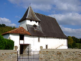
- Aroue-Ithorots-Olhaïby
-
Aroue-Ithorots-Olhaïby

Olhaïby chapel Administration Country France Region Aquitaine Department Pyrénées-Atlantiques Arrondissement Bayonne Canton Saint-Palais Intercommunality Amikuze Mayor Marcel Gégu
(2001–2008)Statistics Elevation 89–231 m (292–758 ft)
(avg. 114 m/374 ft)Land area1 17.85 km2 (6.89 sq mi) Population2 263 (2006) - Density 15 /km2 (39 /sq mi) INSEE/Postal code 64049/ 64120 1 French Land Register data, which excludes lakes, ponds, glaciers > 1 km² (0.386 sq mi or 247 acres) and river estuaries. 2 Population without double counting: residents of multiple communes (e.g., students and military personnel) only counted once. Coordinates: 43°19′09″N 0°54′59″W / 43.3191666667°N 0.916388888889°W
Aroue-Ithorots-Olhaïby (Basque: Arüe-Ithorrotze-Olhaibi) is a commune in the Pyrénées-Atlantiques department in south-western France.
It is located in the former province of Soule.
See also
References
External links
Ainharbe | Aloze-Ziboze-Onizegaine | Altzai-Altzabeheti-Zunharreta | Altzürukü | Arrokiaga | Arüe-Ithorrotze-Olhaibi | Atharratze-Sorholüze | Barkoxe | Berrogaine-Lahüntze | Bildoze-Onizepea | Domintxaine-Berroeta | Eskiula | Espeize-Ündüreine | Etxarri | Etxebarre | Gamere-Zihiga | Garindaine | Gotaine-Irabarne | Hauze | Idauze-Mendi | Iruri | Jestaze | Lakarri-Arhane-Sarrikotagaine | Larraine | Lexantzü-Zünharre | Ligi-Atherei | Liginaga-Astüe | Lohitzüne-Oihergi | Maule-Lextarre | Mendikota | Mitikile-Larrori-Mendibile | Montori | Muskildi | Ospitalepea | Ozaraine-Erribareita | Ozaze-Zühara | Pagola | Sarrikotape | Sohüta | Urdatx-Santa-Grazi | Urdiñarbe | Ürrustoi-Larrebille | Zalgize-Doneztebe
 Categories:
- Communes of Pyrénées-Atlantiques
- Pyrénées-Atlantiques geography stubs
Wikimedia Foundation. 2010.

