- Discovery Islands
-
This article is about the archipelago near Campbell River, B.C.. For other islands with a similar name, see Discovery Island (disambiguation).
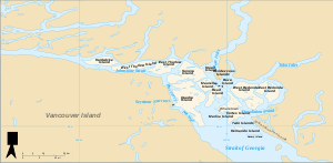 Discovery Islands, between Vancouver Island and continental British Columbia, north of Strait of Georgia
The Discovery Islands are the islands in the Discovery Passage between Vancouver Island and the mainland in British Columbia. These islands are sometimes considered to be part of the Northern Gulf Islands.
The Discovery Passage starts where the Strait of Georgia narrows between Quadra Island and Vancouver Island and continues north until it widens somewhat into the Johnstone Strait. The complex geography of the area can make it difficult to determine when travelling by boat if a sighted coastline belongs to the mainland, Vancouver Island, or one of the Discovery Islands.
Most of these islands have very few residents. The primary attraction to visitors is the salmon fishing and there are numerous fishing lodges. Only Quadra Island and Cortes Island have ferry service. The remainder are served by private boat or float plane.
The Discovery Islands are all located within the Strathcona Regional District, except for a few of the southernmost, such as Hernando Island and Savary Island, which are in the Powell River Regional District. The larger islands within the Discovery Islands are (roughly from west to east, then north to south, with some of the smaller islands indicated next to a nearby larger island):
- Strathcona Regional District
- Hardwicke Island (north: Poyntz, Seymour, Murray; west: Yorke; south: Helmcken)
- West Thurlow Island
- East Thurlow Island (west: Walkem Islands; south: Tum)
- Sonora Island (northwest: Hardinge, Block)
- Stuart Island
- Quadra Island (north: Okis Islands}
- Maurelle Island
- Read Island (east: Hill Island, Penn Islands)
- Rendezvous Islands
- Raza Island
- West Redonda Island (south: Mink, Kinghorn, and the Martin Islands; north: Elizabeth)
- East Redonda Island (south: Melville, Morgan, Eveleigh, Otter, and the William Islands; north: Double, Channel)
- Marina Island
- Cortes Island (west: Subtle Islands)
- Twin Islands
- Powell River Regional District
- Hernando Island (east: Capeland Islands)
- Savary Island
See also
External links
The Discovery Islands of British Columbia Cortes Island · Hardwicke · Hernando · Maurelle Island · Quadra · Read Island · East Redonda · West Redonda Island · Sonora Island · Rendezvous Islands · Stuart Island · East Thurlow Island · West Thurlow Island · Twin IslandsCoordinates: 50°16′41″N 125°09′08″W / 50.27806°N 125.15222°W
 Historical geographic regions of British Columbia
British Columbia Coast Alberni Valley · Central Coast · Comox Valley · Cowichan Valley · Discovery Islands · Fraser Valley · Greater Nanaimo · Greater Vancouver · Greater Victoria · Gulf Islands · Malahat · Skeena Country · North Island · Nass Country · North Coast · Queen Charlotte Islands · Sea-to-Sky Corridor · Sunshine Coast · West Coast of Vancouver IslandBritish Columbia Interior Atlin Country · Boundary Country · Bridge River Country · Bulkley Valley · Cariboo · Cassiar Country · Chilcotin Country · Columbia Country · Fraser Canyon · Kootenays · Liard Country · Lillooet Country · Nechako Country · Nicola Country · Okanagan · Omineca Country · Peace River Country · Robson Valley · Shuswap Country · Similkameen Country · Skeena Country · Slocan Valley · Stikine Country · Thompson CountryCategories:- Discovery Islands
- South Coast of British Columbia
- Central Coast of British Columbia

Wikimedia Foundation. 2010.