- Crow Creek Reservation
-
Crow Creek Indian Reservation — Reservation — 
FlagLocation of Crow Creek Indian Reservation, South Dakota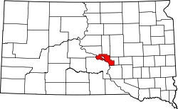
Country United States State South Dakota Counties Buffalo / Hughes / Hyde Government - Governing body Crow Creek Sioux Tribal Council Area - Total 196.235 sq mi (508.248 km2) Population (2004) - Total 1,230 Time zone CST (UTC-6) - Summer (DST) CDT (UTC-5) Website South Dakota Tribal Government Relations: Crow Creek Sioux Tribe The Crow Creek Indian Reservation is located in parts of Buffalo, Hughes, and Hyde counties on the east bank of the Missouri River in central South Dakota in the United States. It has a land area of 421.658 sq mi (1,092.09 km²) and a 2000 census population of 2,225 persons. Its major town and capital of the Crow Creek Sioux Tribe is Fort Thompson, located adjacent to the Big Bend Dam, which holds back Big Bend Reservoir (also known as Lake Sharpe), one of the Missouri Mainstem reservoirs constructed by the US Army Corps of Engineers in the Pick-Sloan Plan.
The people of the Crow Creek Sioux Tribe are a mixture of Dakota and Lakota speaking "Sioux", who settled on the reservation after escape or exile from Minnesota following the Dakota War of 1862 in Minnesota, and were relocated from de-established Indian Reservations further east in South Dakota. Although considered to be a part of the Great Sioux Reservation by some writers, the Crow Creek Reservation, established in 1862, has always been separate.
The reservation originally included bottom lands along the Missouri, which had been farmed by Arikara and other tribes prior to these tribes being wiped out in smallpox and other epidemics in the 18th century; today, several Arikara or Mandan villages are archeological sites on the Crow Creek Reservation. Lake Sharpe flooded much of this land, forcing relocation of Fort Thompson and other settlements, and worsening the economic conditions in the area. Allotment and land sales reduced both the amount of land in tribal and Indian ownership, and even the boundaries of the Reservation shrank between its establishment in 1862 and modern times.
The Reservation, and the Crow Creek Sioux Tribe, is organized into three Districts. The Tribe runs its own school, the Crow Creek Tribal Schools system with an elementary school at Fort Thompson and a K-12 boarding and day school at Stephan, approximately 10 miles (16 km) north of Fort Thompson. Most of the Tribe's land is leased to a few large ranching families, and unemployment is high. The Tribe operates the Lode Star Casino and Hotel and attracts many tourists to the reservation, the archeological sites, Lake Sharpe's fishing and boating, and people traveling. The reservation is located southeast of Pierre, and north of Chamberlain. It is reached via South Dakota Highway 47 or South Dakota Highway 50 off Interstate 90, or via South Dakota Highway 34 east from Pierre.
The Lower Brule Indian Reservation is located immediately across the Missouri River from the Crow Creek Reservation.
A monument at Big Bend Dam dedicated in 2002, the Spirit of the Circle Monument, honors the more than 1,300 people who died of malnutrition and exposure over a three-year period in the 1860s at the reservation following the forcible removal of the Santee Sioux that resulted from their defeat in the Dakota War of 1862.[1]
Oscar Howe, the famous Dakota artist, is from the Crow Creek Reservation.
Contents
Tribal Information
- Reservation: Crow Creek Reservation; Buffalo, Hyde, and Hughes Counties
- Division: Santee, Yankton
- Bands: Mdewakanton (People of Spirit Lake), Ihanktonwan (People of the End)
- Land Area: 125,591 acres (508.25 km2)
- Tribal Headquarters: Fort Thompson, SD
- Time Zone: Central
- Traditional Language: Dakota
- Enrolled members living on reservation: 1,230
- Major Industry: Agriculture
Government
- Charter: None; Constitution and Bylaws: Yes
- Date Approved: April 26, 1949
- Name of Governing Body: Crow Creek Sioux Tribal Council
- Number of members: six (6) council members
- Dates of Constitutional amendments: February 25, 1963, June 23, 1980, February 4, 1986
- Number of Executive Officers: (1) Chairman
Elections
- Election of all six council members and the Chair are held every two years on the third Tuesday in April. Chairman is elected at large by all districts. Tribal Council elects from within a Vice-Chairman, Treasurer and Secretary.
- If terms of office are staggered: No
- Number of Election districts or communities: 3
Council Meetings
- Regular meetings are held once a month.
- Quorum number: 4 members
Leaders: Past and Present
- Oscar Howe, a Yanktonai, pioneered a new era in Indian art. Howe was born on the Crow Creek Reservation in 1915. Throughout his life, he received many honors, including the title Artist Laureate of South Dakota. When he died in 1983, Howe left behind a legacy of cultural heritage and pride. More than 20 Oscar Howe originals are on display at the Oscar Howe Art Center in Mitchell, South Dakota.
- Elizabeth Cook-Lynn taught native studies for 20 years before becoming a full-time writer. She is the author of two novels and a collection of short stories. She edits theWicazo Sa (Red Pencil) Review, an international Native American studies journal. She is also a traditional dancer on the powwow circuit. Cook-Lynn grew up on the Crow Creek Reservation.
See also
References
- ^ Melmer, David (June 19, 2002). "Dakota sacrifice honored". Indian Country Today. http://www.indiancountrytoday.com/archive/28217624.html. Retrieved 2008-09-27.
- Environmental Assessment, Crow Creek Tribal School, Nathan A. Barton, Wasteline, Inc. 2004.
- Crow Creek Reservation, South Dakota United States Census Bureau
External links
- Official Website of the Crow Creek Reservation
- Crow Creek: Stolen Lands, Wind Farms and Taking a Stand for the People—NDN News December 19, 2009.
Coordinates: 44°07′44″N 99°28′26″W / 44.12889°N 99.47389°W
Categories:- Archaeological sites in South Dakota
- Geography of Buffalo County, South Dakota
- Geography of Hughes County, South Dakota
- Geography of Hyde County, South Dakota
- Dakota War of 1862
- American Indian reservations in South Dakota
- Sioux people


Wikimedia Foundation. 2010.