Thicktail chub

Thicktail chub

Taxobox
name = Thicktail chub
status = EX | status_system = IUCN2.3
extinct = 1950s


image_width = 250px
image_caption =
regnum = Animalia
phylum = Chordata
classis = Actinopterygii
ordo = Cypriniformes
familia = Cyprinidae
genus = "Gila"
species = "G. crassicauda"
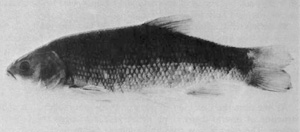
binomial = "Gila crassicauda"

The Thicktail chub ("Gila crassicauda") was a type of minnow that inhabited the lowlands and weedy backwaters of the Sacramento and San Joaquin Rivers in the Central Valley of California. It was once abundant in lowland lakes, marshes, ponds, slow-moving stretches of river, and, during years of heavy run-off, the surface waters of San Francisco Bay. The thicktail chub was one of the most common fish in California; at the turn of the 20th century it comprised over 40% of the fish population of the Sacramento River.

The chub was a favored food of the native Indian peoples of Clear Lake and the Central Valley before being heavily exploited by commercial fishermen supplying the San Francisco market. A heavy-bodied fish with a thick tail and a small, cone-shaped head, the backs of the thicktail chub ranged in color from greenish-brown to purplish black, while the sides and belly were yellow. It could reach a length of nearly ten inches. Although little is known about its behavior, it was probably carnivorous, feeding on small fish and invertebrates.

The primary cause of the thicktailed chub’s extinction was the conversion of much of the Central Valley to agricultural use. Most of its habitat was destroyed by the drainage of sloughs and marshes, dam-building, and water diversion for irrigation. All this resulted in the loss of the sluggish water the species preferred. Competition from exotic species and hybridization with the introduced Hitch minnow also contributed to its extinction. The last known example was caught in the late 1950s.

References

*


Wikimedia Foundation. 2010.

Игры ⚽ Поможем написать реферат

Look at other dictionaries:

  • Cypriniformes — Loach redirects here. For other uses, see Loach (disambiguation). Cypriniformes Temporal range: Paleocene–Recent …   Wikipedia

  • Gila (genus) — Taxobox name = Gila image width = 240px image caption = Bonytail chub, Gila elegans regnum = Animalia phylum = Chordata classis = Actinopterygii ordo = Cypriniformes familia = Cyprinidae subfamilia = Leuciscinae genus = Gila genus authority =… …   Wikipedia

  • Coyote Creek (Santa Clara County) — For other streams in California named Coyote Creek, see Coyote Creek (disambiguation). Coordinates: 37°27′26″N 122°2′56″W / 37.45722°N 122.04889°W …   Wikipedia

  • List of extinct animals of North America — This is an incomplete list of extinct animals of North America. This list covers only extinctions from the Holocene epoch, a geological period that extends from the present day back to about 10,000 radiocarbon years, approximately 11,430 ± 130… …   Wikipedia

  • Alcatraz Island — Alcatraz redirects here. For other uses, see Alcatraz (disambiguation). Alcatraz Island IUCN Category V (Protected Landscape/Seascape) …   Wikipedia

  • Treasure Island (California) — Coordinates: 37°49′N 122°22′W / 37.82°N 122.37°W / 37.82; 122.37 …   Wikipedia

  • San Joaquin River — Coordinates: 38°04′00″N 121°51′04″W / 38.0666667°N 121.85111°W / 38.0666667; 121.85111 …   Wikipedia

  • Angel Island (California) — Angel Island Angel Island Geography Location San Francisco Bay Coordinates …   Wikipedia

  • Napa River — Coordinates: 38°4′12″N 122°14′38″W / 38.07°N 122.24389°W / 38.07; 122.24389 …   Wikipedia

  • Don Edwards San Francisco Bay National Wildlife Refuge — Coordinates: 37°30′N 122°07′W / 37.5°N 122.117°W / 37.5; 122.117 …   Wikipedia

Share the article and excerpts

Direct link
Do a right-click on the link above
and select “Copy Link”