- Mosteiros, Cape Verde (municipality)
-
Mosteiros Municipality Country Cape Verde Island Fogo Seat town Mosteiros Area 82 km2 (32 sq mi) Population 17,449 (2005) ISO 3166-2 code CV-MO CGN-CV code 283 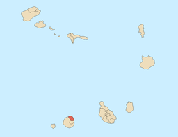
Website: http://www.mosteiros.com Mosteiros is a municipality located in the northeastern part of the island of Fogo in Sotavento in southern Cape Verde. The municipal population is around 9,449. The seat of the municipality is Vila dos Mosteiros.
Mosteiros is linked with a highway that almost encircles the whole island of Fogo but it is inaccessible to the southeast by small narrow gravel stretch. Farmlands are within the coastline while the rocky landscape with a few bushes and grasslands of Mount Fogo lies to the southwest. Mosteiros contains one of the few forests in Cape Verde, named Floresta de Monte Velha. The entire terrain are made up of historic lava flows from Mount Fogo which resulted from the last volcanic eruption in 1951.
Its main economy are agriculture in which 96% of its inhabitants are made up of rural population, tourism and businesses are the next industry but in very small numbers and the living standards and the income are very low making it the least developed island in all of Cape Verde. The main production is dedicated to coffee cultivation, which has Café do Fogo (Fogo Coffee). The illiteracy rate is very high and is one of the highest in Cape Verde. 31% of the population are over the age of 15. Very few homes do not have appliances or electricity, newspaper circulation or communications including television, radio or a computer, prior to the 20th century, Mosteiros didn't had appliances or electronics and do not own as much automobiles and household items. The population between 2001 and 2005 only added 12 to the 2001 population of 465 making it 477 which the main reason is lack of standard of living.
Contents
Parishes
The municipality includes only one parish:
Settlements
History
It was created in 1991, when the older Municipality of Fogo was split in two, the southwestern part becoming the Municipality of São Filipe and the northeastern part becoming the Municipality of Mosteiros.
Demography
Population of Mosteiros, Cape Verde (municipality) (1940—2010) 1940 1950 1960 1970 1980 1990[1] 2000[2] 2010[3] — — — — — 10331 13535 17449 External links
- http://www.mosteiros.com
- ANMCV (Associação Nacional dos Municípios Cabo-Verdianos - National Association of the Capeverdean Municipalities)
North: Atlantic Ocean West: São Filipe Mosteiros East: Atlantic Ocean Southwest: São Filipe South: Santa Catarina do Fogo References
- ^ Source: Statoids
- ^ Source: Instituto Nacional de Estatísticas.
- ^ Source: projection to 2010 from the Instituto Nacional de Estatísticas.
Municipalities of Cape Verde Municipalities Boa Vista · Brava · Maio · Mosteiros · Paul · Porto Novo · Praia · Ribeira Grande · Sal · Santa Catarina · Santa Cruz · São Domingos · São Filipe · São Miguel · São Vicente · Tarrafal
New municipalities
(2005)Ribeira Brava · Ribeira Grande de Santiago · Santa Catarina do Fogo · São Lourenço dos Órgãos · São Salvador do Mundo · Tarrafal de São Nicolau
Coordinates: 15°02′00″N 24°19′30″W / 15.0333333°N 24.325°W
Categories:- Cape Verde geography stubs
- Municipalities of Cape Verde
- Fogo, Cape Verde

Wikimedia Foundation. 2010.