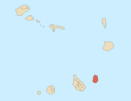
Maio, Cape Verde (municipality)
- Maio, Cape Verde (municipality)
-
| Maio |
| Municipality |
| Country |
Cape Verde |
| Island |
Maio |
|
| Seat town |
Vila do Maio |
|
| Area |
269 km2 (104 sq mi) |
|
| Population |
5,435 (2005) |
| Density |
20 / km2 (52 / sq mi) |
|
| ISO 3166-2 code |
CV-MA |
| CGN-CV code |
61 |
|
| Demonym |
Maiense, ~s pl |
|
|
|
| Website: www.anmcv.org |
|
The whole island of Maio makes up the Maio Municipality.
Parishes
The municipality includes only one parish:
Demography
| Population of Maio, Cape Verde (municipality) (1940—2010) |
| 1940[1] |
1950[1] |
1960[1] |
1970[1] |
1980[1] |
1990[1] |
2000[2] |
2010[3] |
| 2237 |
1924 |
2680 |
3466 |
4098 |
4969 |
6754 |
8303 |
References
| v · d · eMunicipalities of Cape Verde |
|
| Municipalities |
|
|
New municipalities
(2005) |
|
|
Categories: - Cape Verde stubs
- Municipalities of Cape Verde
Wikimedia Foundation.
2010.
Look at other dictionaries:
Mosteiros, Cape Verde (municipality) — Mosteiros Municipality Country Cape Verde Island Fogo … Wikipedia
Cape Verde — This article is about the country. For the surface feature on Mars, see Cape Verde (Mars). For weather pattern, see Cape Verde type hurricane. Republic of Cape Verde República de Cabo Verde (Portuguese) … Wikipedia
Morro, Cape Verde — Morro Morr Statistics Island: Maio Municipality: Maio Parish: Nossa Senhora da Luz … Wikipedia
Administrative divisions of Cape Verde — Cape Verde This article is part of the series: Politics and government of Cape Verde President Jorge Carlos Fonseca … Wikipedia
Portal:Cape Verde — Wikipedia portals: Culture Geography Health History Mathematics Natural sciences People Philosophy Religion Society Technology … Wikipedia
Sal, Cape Verde — Geobox|Island name = Sal country = Cape Verde country highest location = Monte Vermelho highest elevation = 406 coordinates type = isle lat d = 16 |lat m = 43 |lat NS = N long d = 22 |long m = 56 |long EW = W area = 216 length = 30 length… … Wikipedia
São Francisco, Cape Verde — São Francisco (Portuguese meaning Saint Francis, in Cape Verdean Creole: Son Fransisku ) is a village situated at the southeast of Santiago Island in Cape Verde. It is part of the municipality of Praia. The village is linked with the road linking … Wikipedia
Achada, Santiago, Cape Verde — Achada (in Cape Verdean Creole, written in ALUPEC: Txada ) is a village situated at the east of Santiago Island in Cape Verde. The village is linked with the road linking Praia and Tarrafal which is approximately 40 km away from the… … Wikipedia
Nossa Senhora da Luz (Maio) — For other uses, see Nossa Senhora (disambiguation). Nossa Senhora da Luz Statistics Island: Maio Municipality: Maio Altitude: Lowest: Centre: H … Wikipedia
Coimbra Municipality — Coordinates: 40°13′31.69″N 8°27′8.24″W / 40.2254694°N 8.4522889°W / 40.2254694; 8.4522889 … Wikipedia