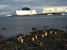
- Danco Island
-
Danco Island 
Geography Location Antarctica Coordinates 64°44′S 62°37′W / 64.733°S 62.617°W Length 1.0 mi (1.6 km) Country Demographics Population 0 Additional information Administered under the Antarctic Treaty System Danco Island or Isla Dedo is an island off Antarctica, 1 mile (1.6 km) long lying in the southern part of Errera Channel, off the west coast of Graham Land. Danco Island is located at 64°44′S 62°37′W / 64.733°S 62.617°W. Danco Island was charted by the Belgian Antarctic Expedition under Adrien de Gerlache, 1897-1899. Danco Island was surveyed by the Falkland Islands Dependencies Survey (FIDS) from the Norsel in 1955, and named by the United Kingdom Antarctic Place-names Committee (UK-APC) for Emile Danco (1869-1898), Belgian geophysicist and member of the Belgian Antarctic Expedition, who died on board the Belgica in the Antarctic.
See also
- Composite Antarctic Gazetteer
- List of Antarctic and sub-Antarctic islands
- List of Antarctic islands south of 60° S
- SCAR
- Territorial claims in Antarctica
References
External links

This Danco Coast location article is a stub. You can help Wikipedia by expanding it.
