- Markfield
-
Coordinates: 52°41′16″N 1°16′39″W / 52.687802°N 1.277510°W
Markfield 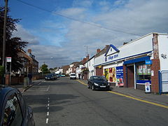
Main Street, Markfield, Leicestershire, England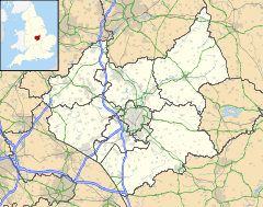
 Markfield
Markfield shown within LeicestershirePopulation 4,474 [1] OS grid reference SK488103 Parish Markfield District Hinckley and Bosworth Shire county Leicestershire Region East Midlands Country England Sovereign state United Kingdom Post town MARKFIELD Postcode district LE67 Dialling code 01530 Police Leicestershire Fire Leicestershire Ambulance East Midlands EU Parliament East Midlands List of places: UK • England • Leicestershire Markfield is a commuter village sitting within both the National Forest and Charnwood Forest and in the Hinckley and Bosworth district of Leicestershire, England. The settlement dates back to at least the time of the Norman conquest and is mentioned in the Domesday Book under the name Merchenefeld. A variant of this is still used as the name for the village primary school, Mercenfeld. It is to the south-east of Junction 22 of the M1, and to the south of the A50. Nearby places are Newtown Linford, Groby, Field Head, and Stanton under Bardon. In the 1831 census its population was recorded at 1,088. [1] The modern civil parish in the 2001 census had a population of 4,474.[1] Markfield is within the LE67 postcode district. In early 2010 Hinckley & Bosworth Borough Council began a review of the Markfield Conservation Area, involving an exhibition where members of the public could offer their opinions of the review. The council stated the purpose of the review was to “...provide a sound basis for decisions on future development proposals, help to develop initiatives to improve the area and provide an educational and informative document for the local community.” [2]
Facilities
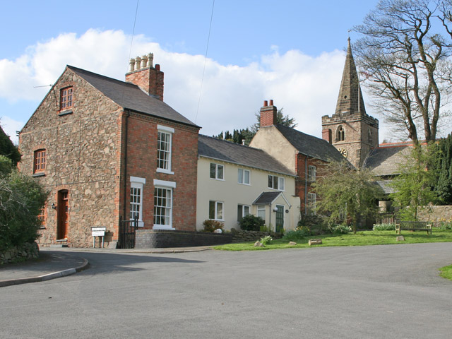
 The Green and St Michael and All Angels' Church, Markfield
The village of Markfield has three pubs – The Red Lion, The Queens Head and The Bulls Head – and a Travelodge hotel; the parish contains a fourth pub – the Coach and Horses in Field Head. The Fieldhead Hotel adjoins Markfield, but is on the Newtown Linford side of the boundary. Markfield has Chinese and Indian takeaways, a fish and chip shop, a newsagent, a florist, Just Naturally Healthy - an independent shop selling organic produce, a Co-Operative Supermarket, a financial advisory office, a GP surgery, a chemist, a Londis supermarket, a Post Office, a newly built and equipped library and a cafe called the Markfield Bakery. There are also several hair-dressing salons and an industrial estate. Markfield has a well-funded and run Community Centre which has just been extended and refurbished. This Centre was built in 1985 and in time has replaced the old Markfield Memorial Miners Institute as the main community building in the village. Until recently the village also had a small hardware shop, which had been empty for sometime. The premises are now being refurbished for a new hardware and homeware shop to be called Bown2have it.
Markfield has close links with the Methodist movement and was often a stopping point for its founder John Wesley (see blue plaque on parish church) He was allowed to preach in the parish church but as his visits became popular he would preach on the village green. Today Markfield has the parish church of St Michaels and all Angels, Holy Trinity Methodist chapel and the Congregational church. The original Methodist chapel (temperance hall) is no longer used. At one time there were actually two Methodist chapels in the village. Markfield is also the setting of the renowned Dawah Centre otherwise known as the Islamic Foundation and institute of higher education. The centre is linked with Loughborough University and runs degree courses in Islamic finance and banking. The Library is thought to be the finest Islamic library in Western Europe. The most recent wing of institute was opened by HRH Prince Charles in 2004.
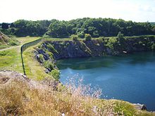 Hill Hole Quarry & Nature Reserve (23/6/09)
The village benefits greatly from being surrounded by easily accessible countryside. There are a variety of public footpaths radiating out from the village - including the "Leicestershire Round", which passes along Main Street. To the north-western side of the village lies the Hill Hole Nature Reserve. Hill Hole is the highest point within the village and from the top of this quarried granite outcrop there are extensive views across the Midland Plain (43 miles to the Clent Hills), southwards to the Cotswold and westwards towards the Leicestershire/Lincolnshire boundary. Almost adjoining Hill Hole are the Altar Stones playing fields and the Blacksmiths Fields nature reserve.
Markfield has a long association with the quarrying industry and has a particular type of granite (microdiorite) named after it. The granite stone (microdiorite) 'Markfieldite' is a very hard granite found in the local area and used in roadstone and railway construction. The former headquarters of Aggregate Industries (now under the Holcim company) was in Markfield and currently proposals are being discussed to expand the Bardon Hill Quarry into the parish of Markfield to create a large extension which would expand the life of Bardon for another 40 years.[citation needed]
In 2009, a private contractor filed for permission to build a brand new housing estate by London Road. A petition to prevent such housing being built took place, arguing that the local primary school, public transport and other services could not cope with the large influx of new residents. The petition to prevent the housing development failed, and the contractors have moved into the next stage of planning the estate.
See also
References
Categories:- Villages in Leicestershire
- Civil parishes in Leicestershire


Wikimedia Foundation. 2010.