- Cliffe Hill Mineral Railway
-
Cliffe Hill Mineral Railway 
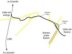
Map of the Cliffe Hill Mineral Railway
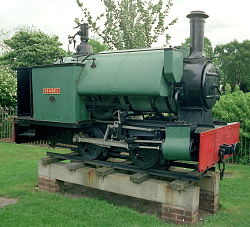
Cliffe Hill Mineral Railway locomotive Isabel, preserved on a plinth in Stafford in 1974.Locale England Dates of operation 1896–1948 Successor abandoned Track gauge 2 ft (610 mm) Headquarters Stanton under Bardon The Cliffe Hill Mineral Railway was an industrial narrow gauge railway that connected the Cliffe Hill granite quarry to the nearby London Midland and Scottish Railway (LMS) between Leicester and Coalville. The line opened in 1896 and operated until 1948.
Contents
History
Granite is reputed to have been quarried from the outcrop near Markfield in Leicestershire since Roman times. However it was not until the 1860s that quarrying began on a commercial scale. In the late 1870s two Birmingham businessmen opened a quarry at Cliffe Hill to provide street setts and kerb stones. This quarry closed in 1887 but was revived in 1889 by Mr. J. Rupert Fitzmaurice the son of one of the original owners. Fitzmaurice equipped the quarry with then modern machinery and it quickly became a commercial success.
In the first year of the new operation 630 tons of finished kerbs and 10,200 tons of broken stone were produced. Most of this was taken by horse and cart to Bagworth station 2½ miles away for transit by rail. In 1892 a traction engine was purchased to help transport stone to the railway.
Over the next few years demand for the company's products continued to increase and road transportation became a bottleneck to increasing production. The board decided to build its own railway line to move stone from the quarry to the nearest LMS line. The route to Bagworth Station would have required heavy gradients and passed over land owned by Mr. Breedon Everard, who was hostile to the notion of a railway. So the decision was made to build the line south from the quarry to a transshipment point at Beveridge Lane, near Bardon Hill station.
Construction started on the line in early 1896 and by the end of the year the first steam locomotive had been delivered and was at work.
The line from the quarry to the LMS's Cliffe Hill sidings remained substantially unchanged for the life of the railway, with the exception of an embankment built in 1911 to avoid steep gradients as the line crossed a small valley near Hillcroft farm.
The railway served its purpose for more than fifty years, employing a wide range of locomotives to move the granite trains. During the Second World War quarry production was reduced due to the lack of available workers. At the end of the war there was a boom in the housing and roads construction industries as wartime damage was repaired. This created a strong demand for the quarry's products. At the same time new quarrying and transportation machinery was becoming available and the company decided to reorganize production methods.
Within the quarry, lorries quickly replaced the internal railway, and by 1948 road transport was quickly replacing the need for the line between the quarry and the standard gauge railway. The decision was taken to abandon the Cliffe Hill Mineral Railway, and the last train ran in March of that year.
The track remained in situ for several years, and most of it was taken up in the mid 1950s.
Locomotives
Name Builder Type Works Number Built Disposal Notes Cliffe W.G. Bagnall 0-4-0ST 1487 1896 Sold to Bardon Hill Quarry in 1946, scrapped in 1953 Isabel W.G. Bagnall 0-4-0ST 1491 1897 Returned to Bagnall's in 1953, now preserved at the Amerton Railway The Rocket W.G. Bagnall 0-4-0ST 1531 1898 Scrapped 1957 Edith W.G. Bagnall 0-4-0ST 1589 1900 Scrapped 1935 Jack W.G. Bagnall 0-4-0ST 1650 1901 Sold to Graham's Moor Quarry, Criggion, 1916 Mary W.G. Bagnall 0-4-2T 1943 1911 Scrapped 1957 Gelakey No.1 Baguley 4wPM 434 1914 Scrapped 1957 Used at the quarry for a makers test in February 1914. Jack W.G. Bagnall 0-4-2T 2034 1915 Scrapped 1957 Mabel W.G. Bagnall 0-4-0ST 2077 1918 Scrapped 1948 Acquired from the Ministry of Munitions, Stamford Aerodrome, 1920 Peter W.G. Bagnall 0-4-0ST 2067 1918 Now preserved at Amberley Museum Railway. Built for the Canadian Forestry Commission as 3' gauge. Acquired 1920 Samson later Tug Sentinel 4wGVB 6770 1926 Scrapped 1957 Sentinel 4wGVB 6751 1926 Edith Sentinel 4wGVB 6902 1927 Scrapped 1957 Acquired from Durham County Water Board, Burnhope Reservoir railway 1935 Kashmir Kerr Stuart 0-6-0T 3118 1918 Scrapped 1957 Originally worked on the Kerry Tramway, later at the Stamford Aerodrome, acquired in 1941 Orenstein & Koppel 4wDM Presumed scrapped in 1957 From Thomas Ward, Sheffiled around 1940 See also
- British quarrying and mining narrow gauge railways
References
- Billington, M.H. (1997). The Cliffe Hill Mineral Railway (2nd. Edition ed.). Plateway Press. ISBN 1-871980-23-2.
Categories:- 2ft gauge railways
- Industrial railways in England
- Railway lines opened in 1896
- Railway lines closed in 1948
Wikimedia Foundation. 2010.
