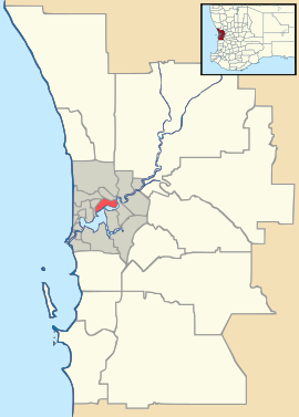
Martin, Western Australia

Martin, Western Australia
Martin
PerthWestern Australia
Martin is located in Perth
{{{alt}}}
Martin
Population: 1,199 (2006 census)
Postcode: 6111
LGA: City of Gosnells
State District: Kalamunda
Federal Division: Canning
Suburbs around Martin:
Maddington Orange Grove Canning Mills
Gosnells Martin Canning Mills
Kelmscott Kelmscott Roleystone

Coordinates: 32°04′16″S 116°02′13″E / 32.071°S 116.037°E / -32.071; 116.037

Martin is a suburb of Perth, Western Australia, located within the City of Gosnells. It was named in 1974 after a pioneer family of the Gosnells district, and in particular Edward Victor Martin who had served for 37 years on the council.[1]

References


Wikimedia Foundation. 2010.

Игры ⚽ Нужен реферат?

Look at other dictionaries:

  • Duncraig, Western Australia — This article is about a suburb of Perth, Western Australia.. For Duncraig Castle in Scotland, see Plockton. Duncraig Perth, Western Australia …   Wikipedia

  • Hamersley, Western Australia — Infobox Australian Place | type = suburb name = Hamersley city = Perth state = wa caption = View east from Benjafield Way towards ABC tower lga = City of Stirling area = 3.267 postcode= 6022 pop = 4,965 (2006 census) dist1 = 14 | dir1 = NNW |… …   Wikipedia

  • Northam, Western Australia — Northam Western Australia …   Wikipedia

  • Thornlie, Western Australia — Thornlie Perth, Western Australia Thornlie Square shopping centre …   Wikipedia

  • Kelmscott, Western Australia — Infobox Australian Place | type = suburb name = Kelmscott city = Perth state = wa caption = lga = City of Armadale postcode = 6111 pop = 9,417 (2006 census) area = 15.9 est = propval = $333,000 (Q1 2007) cite web|url=http://reiwa.com/res/res… …   Wikipedia

  • Esperance, Western Australia — Infobox Australian Place | type = town name = Esperance state = wa lga = Shire of Esperance mayor = Ian Mickel est = 1896 postcode = 6450 pop = 9536 maxtemp = 21.2 mintemp = 11.4 rainfall = 676.2 fedgov = Kalgoorlie stategov = Eyrecoord|… …   Wikipedia

  • Williams, Western Australia — Infobox Australian Place | type = town name = Williams caption = lga = Shire of Williams est = 1860s postcode = 6391 pop = 329 dist1 = 161 | dir1 = SSE | location1 = Perth dist2 = 32 | dir2 = W | location2 = Narrogin fedgov = Pearce stategov =… …   Wikipedia

  • Roleystone, Western Australia — Infobox Australian Place | type = suburb name = Roleystone city = Perth state = wa caption = lga = City of Armadale area = 12.2 postcode= 6111 pop = 5,975 (2006 census) dist1 = 30 | dir1 = SE | location1=Perth dist2 = 8 | dir2 = NE |… …   Wikipedia

  • Westfield, Western Australia — Infobox Australian Place | type = suburb name = Westfield city = Perth state = wa caption = lga = City of Armadale postcode = 6111 pop = 4,523 (2006 census) area = 2.5 est = propval = $283,000 (Q1 2007) cite web|url=http://reiwa.com/res/res… …   Wikipedia

  • Karragullen, Western Australia — Infobox Australian Place | type = suburb name = Karragullen city = Perth state = wa caption = A fruit shed and orchard in Karragullen. lga = City of Armadale postcode = 6111 pop = 250 (2006 census) area = est = propval = stategov = Darling Range… …   Wikipedia

Share the article and excerpts

Direct link
Do a right-click on the link above
and select “Copy Link”