- Oudesluis (Zijpe)
-
Oudesluis — Village — 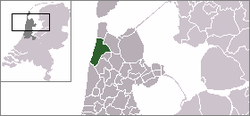 The village centre (darkgreen) and the statistical district (lightgreen) of Oudesluis in the municipality of Zijpe.
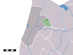
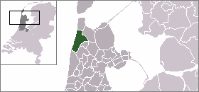
Coordinates: 52°50′N 4°49′E / 52.833°N 4.817°ECoordinates: 52°50′N 4°49′E / 52.833°N 4.817°E Country Netherlands Province North Holland Municipality Zijpe Population – Total 800 Time zone CET (UTC+1) – Summer (DST) CEST (UTC+2) Postal code Oudesluis is a village in the Dutch province of North Holland. It is a part of the municipality of Zijpe, and lies about 13 km south of Den Helder.
In 2001, the village of Oudesluis had 538 inhabitants. The built-up area of the village was 0.11 km², and contained 192 residences.[1] The wider statistical area of Oudesluis has a population of around 800.[2] This includes the hamlet of Keinsmerbrug.
References
- ^ Statistics Netherlands (CBS), Bevolkingskernen in Nederland 2001 [1]. Statistics are for the continuous built-up area.
- ^ Statistics Netherlands (CBS), Gemeente Op Maat 2004: Zijpe [2].
Villages Burgerbrug - Callantsoog - Oudesluis - Petten - Schagerbrug - Sint Maartensbrug - Sint Maartensvlotbrug - 't ZandHamlets Abbestede - Burgervlotbrug - 't Buurtje - Groote Keeten - Keinsmerbrug - Het Korfwater - Leihoek - Mennonietenbuurt - Sint Maartenszee - De Stolpen - Stolpervlotbrug - ZijpersluisCategories:- Populated places in North Holland
- North Holland geography stubs

Wikimedia Foundation. 2010.