- Zijpe
Infobox Settlement
official_name = Zijpe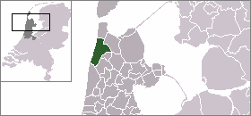
mapsize = 280px
flag_size = 120x100px
image_shield = Zijpe wapen.png
subdivision_type = Country
subdivision_name =Netherlands
subdivision_type1 = Province
subdivision_name1 =North Holland
leader_name = A.M. van Apeldoorn-Pruijt
leader_party = PvdA
area_footnotes = (2006)
area_total_km2 = 113.35
area_land_km2 = 95.17
area_water_km2 = 18.18
population_as_of =1 January ,2007
population_note = Source: CBS, [http://statline.cbs.nl/ Statline] .
settlement_type = Municipality
population_total = 11565
population_density_km2 = 122
timezone = CET
utc_offset = +1
timezone_DST = CEST
utc_offset_DST = +2
latd = 52.80
latNS = N
longd = 4.77
longEW = E
website = [http://www.zijpe.nl www.zijpe.nl].
Population centres
The municipality of Zijpe consists of the following cities, towns, villages and/or districts:
Burgerbrug ,Burgervlotbrug ,Callantsoog ,Groote Keeten , Oudesluis,Petten ,Schagerbrug ,Sint Maartensbrug ,Sint Maartensvlotbrug ,'t Zand .Local government
The municipal council of Zijpe consists of 15 seats, which are divided as follows:
* BKV - 5 seats
* CDA - 5 seats
* PvdA - 3 seats
* VVD - 2 seats
Wikimedia Foundation. 2010.