- Eastern Ore Mountains
-
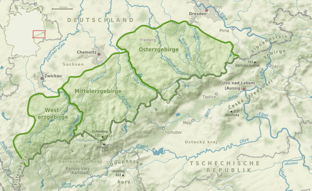
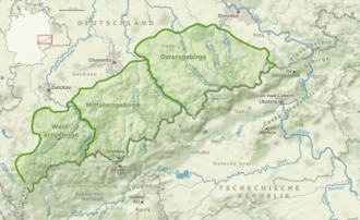 Map of the natural regions in the Ore Mountains
The Eastern Ore Mountains (German: Osterzgebirge) form a natural region that covers the eastern part (in area almost the eastern half) of the Saxon Ore Mountains. It is part of the major landscape unit, the Saxon Highlands and Uplands. Its southern continuation covers an area of roughly the same extent in the Czech Republic.
The Eastern Ore Mountains is bounded in the west by the (excluded) valley of the river Flöha and in the east by Saxon Switzerland, the German (northern) side of the Elbe Sandstone Mountains. The boundary with the Ore Mountain Foreland to the north is rather unclear, whilst in the south the crest of the mountain range closely follows the state border with Czechia.[1]
The highest point on the Czech side is the Loučná (Wieselstein, 956 m n.m.). On the German (Saxon) side of the border the 905 m high Kahleberg is the highest elevation.
The upper regions of the Eastern Ore Mountains in the district of Mittelsachsen are part of the Ore Mountains/Vogtland Nature Park.
Contents
Settlements
- Altenberg
- Bärenstein
- Brand-Erbisdorf
- Bobritzsch
- Cämmerswalde
- Dippoldiswalde
- Eppendorf
- Frauenstein
- Freiberg
- Fürstenwalde
- Gahlenz
- Geising
- Glashütte/Sa.
- Hermsdorf/Erzgeb.
- Holzhau
- Kipsdorf
- Lauenstein
- Liebenau
- Mulda/Sa.
- Nassau
- Neuhausen/Erzgeb.
- Oberschöna
- Oederan
- Olbernhau
- Pfaffroda
- Rechenberg-Bienenmühle
- Rehefeld-Zaunhaus
- Reinhardtsgrimma
- Sayda
- Schellerhau
- Schmiedeberg
- Zinnwald
Rivers and lakes
- Bobritzsch
- Flöha
- Freiberger Mulde
- Lockwitzbach
- Müglitz
- Rote Weißeritz
- Müglitz Valley Retention Basin
- Striegis
- Saidenbach Reservoir
- Rauschenbach Reservoir
- Lichtenberg Reservoir
- Lehnmühle Reservoir
- Klingenberg Reservoir
- Malter Reservoir
- Trebnitz
- Unterer Großhartmannsdorfer Teich
- Wilde Weißeritz
Nature reserves
 The character of the entire Ore Mountains as a fault-block is very clearly seen from the Mückenberg on the Czech side of the range
The upper areas of the Eastern Ore Mountains are part of the Ore Mountains/Vogtland Nature Park and include the following nature reserves:
- Black Grouse reserve of Fürstenau
- Fürstenau Heath nature reserve
- Protected mountain meadows in the Eastern Ore Mountains - a major conservation area with its own unique linear cairns
- Geisingberg nature reserve
- Georgenfelder Hochmoor
See also
- Central Ore Mountains
- Western Ore Mountains
- List of mountains in the Ore Mountains
- List of mountains in Saxony
- Saxon Highlands and Uplands
References
- ^ Map of the natural regions in Saxony at www.umwelt.sachsen.de (pdf, 859 kB)
General sources
- Federal Agency for Nature Conservation (BfN)
- Map services
- Landscape fact files:
- Upper regions of the Eastern Ore Mountains
- Lower regions of the Eastern Ore Mountains
- Tharandt Forest (in the north of the Eastern Ore Mountains)
Literature
- Peter Rölke (Hrsg.): Wander- & Naturführer Osterzgebirge, Berg- & Naturverlag Rölke, Dresden 2007, ISBN 978-3-934514-20-1
- Grüne Liga Osterzgebirge: Naturführer Ost-Erzgebirge. Band 1: Tiere und Pflanzen des Ost-Erzgebirges. Sandstein Verlag, Dresden 2007, ISBN 978-3-940319-16-6 (enthält über 750 Artenbeschreibungen) Digitalisat (pdf-Dateien der einzelnen Kapitel)
- Grüne Liga Osterzgebirge: Naturführer Ost-Erzgebirge. Band 2: Natur des Ost-Erzgebirges im Überblick. Sandstein Verlag, Dresden 2007, ISBN 978-3-940319-17-3 (umfangreiche Darstellung zu Klima, Geologie, Kulturlandschaftsentwicklung) Digitalisat (pdf-Dateien der einzelnen Kapitel)
- Grüne Liga Osterzgebirge: Naturführer Ost-Erzgebirge. Band 3: Naturkundliche Wanderziele. Sandstein Verlag, Dresden 2007, ISBN 978-3-940319-18-0 (detaillierte Darstellung von 26 Teilgebieten des Naturraumes) Digitalisat (pdf-Datei, 14.7 MB)
- Erhard Unger: Die Klimaverhältnisse des östlichen Erzgebirges. in: Sächsische Heimatblätter, Heft 6/1975, S. 287-290
External links
Categories:- Central Uplands
- Mountain ranges of Germany
- Ore Mountains
- Natural regions of Germany

Wikimedia Foundation. 2010.