Rote Weißeritz

Rote Weißeritz

Infobox River
river_name = Rote Weißeritz


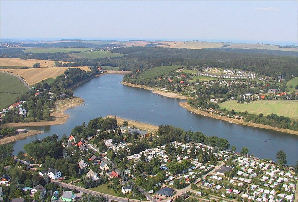
caption = The Talsperre Malter (Malter reservoir)
origin = Eastern Ore Mountains
mouth = Weißeritz
basin_countries = Germany
length = 36,5 km
elevation = 787 m
discharge =
watershed = 161,2 km²

The Rote Weißeritz (Red Weißeritz) is a river in Saxony which drains the eastern Ore Mountains. It is a right tributary of the Weißeritz and 36,5 km in length. The source of the river is next to Altenberg at about 787 metres elevation.

The river has a fall of 606 metres on its north-western directed way running through Schmiedeberg, the district town of Dippoldiswalde and ending in Freital where it forms the Weißeritz together with the longer tributary Wilde Weißeritz. The Malter reservoir was build between 1908 and 1913 between Dippoldiswalde and Freital for flood protection reasons after the 1897 floods.

The deep valley is an important way for traffic and transport. It is a historic inlet to a major mountain pass over the Ore Mountains ("Graupener Pass"). The Weisseritz railway runs through the Weißeritz valley up to Kurort Kipsdorf getting over about 350 metres in altitude difference. The Bundesstraße 170 takes course at the river's banks between Dippoldiswalde and Bärenfels where it leaves the valley by climbing in three hairpin turns.

The Rote Weißeritz caused massiv destruction during the 2002 European floods. Housings and esspecially traffic infrastructure was area-wide destroyed or damaged. The flood reserve of the Malter reservoir was completely spread. The area around the source of the river received a 24-hours-precipitation of up to 312 mm in height.


Wikimedia Foundation. 2010.

Игры ⚽ Нужна курсовая?

Look at other dictionaries:

  • Rote Weißeritz — Die Rote Weißeritz in SchmiedebergVorlage:Infobox Fluss/KARTE fehlt …   Deutsch Wikipedia

  • Weißeritz — (vereinigte) Mündung der Weißeritz in die Elbe in DresdenVorlage:Infobox Fluss/KARTE fehlt …   Deutsch Wikipedia

  • Weißeritz-Park — Weißeritz Park …   Deutsch Wikipedia

  • Weißeritz —   die, linker Nebenfluss der Elbe, in Sachsen, Quellfluss ist die Wilde Weißeritz (53 km) mit den Talsperren Lehnmühle (Stauseefläche 1,35 km2, Stauraum 21,9 Mio. m3) und Klingenberg (entsprechend 1,16 km2 und 16,4 Mio. m3), ab der Vereinigung… …   Universal-Lexikon

  • Weißeritz — Infobox River river name = (Vereinigte) Weißeritz caption = The Weißeritz estuary in Dresden. origin = Wilde Weißeritz and Rote Weißeritz mouth = Elbe basin countries = Germany length = 12 km (61 km incl. Wilde Weißeritz) elevation = 188 m… …   Wikipedia

  • Wilde Weißeritz — in Tharandt Origin Eastern Czech Ore Mountains Mouth Weißeritz …   Wikipedia

  • Weisseritztalbahn — Freital Hainsberg–Kurort Kipsdorf Ausschnitt der Streckenkarte Sachsen von 1902 Kursbuchstrecke (DB): 513 Streckennummer: 6966; sä. HK …   Deutsch Wikipedia

  • Weißeritztalbahn — Freital Hainsberg–Kurort Kipsdorf Ausschnitt der Streckenkarte Sachsen von 1902 Kursbuchstrecke (DB): 513 Streckennummer (DB): 6966; sä. HK …   Deutsch Wikipedia

  • Borlasbach — Der Borlasbach 150 m vor der Mündung in die WeißeritzVorlage:Infobox Fluss/KARTE fehlt …   Deutsch Wikipedia

  • Liste der europäischen Flüsse — Die Liste europäischer Flüsse enthält nach Mündungsgebieten alphabetisch aufgeführte Fließgewässer, die als europäisch gelten, wenn sie zumindest teilweise dem europäischen Kontinent zuzuordnen sind. Nebenflüsse sind von der Mündung in Richtung… …   Deutsch Wikipedia

Share the article and excerpts

Direct link
Do a right-click on the link above
and select “Copy Link”