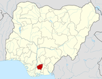
Oru West

Oru West
Oru West
—  LGA  —
Country  Nigeria
State Imo State
Capital
Time zone WAT (UTC+1)

Oru West is a Local Government Area of Imo State, Nigeria. Its headquarters are in the town of Mgbidi.

It has an area of 93 km2 (36 sq mi) and a population of 117,492 at the 2006 census.

The postal code of the area is 474.[1]

References


Wikimedia Foundation. 2010.

Игры ⚽ Поможем написать реферат

Look at other dictionaries:

  • Oru West — Admin ASC 2 Code Orig. name Oru West Country and Admin Code NG.28.7729961 NG …   World countries Adminstrative division ASC I-II

  • Ozara, Oru West — is a town in Oru West Local Government Area of Imo State, Nigeria. It comprises seven villages, namely: Umuobioma, Umuezike, Umuogu, Umuokporoma, Etitilabu, Ubahalanuwam, and Aboh. It has three elementary schools, which are Town School, Central… …   Wikipedia

  • Oru East —   LGA   Country  Nigeria State Imo …   Wikipedia

  • Owerri West —   LGA   Country  Nigeria State I …   Wikipedia

  • Lily of the West — is a traditional American folk song about a man who travels to Louisville and falls in love with a young girl named Flora, the eponymous Lily of the West. He catches Flora being unfaithful to him, and, in a fit of rage, stabs the man she is with …   Wikipedia

  • Orsu — Awo Idemili HQTR   LGA   Nickname(s): Osu Manu Country …   Wikipedia

  • Mgbidi — is the headquarters of Oru West, a Local Government Area of Imo State located in the southeastern region of Nigeria. It is located within Latitude 5.37 N and Longitude 6.57 E. It was the headquarters of the then Oru Local Government Area before… …   Wikipedia

  • Local Government Areas of Nigeria — Local Government Areas of Nigeria …   Wikipedia

  • Local Government Areas in Nigeria — Die Local Government Areas Nigerias in der Übersicht Die Verwaltungsgliederung von Nigeria teilt die Bundesrepublik Nigeria seit 1996 in 774 Local Government Areas (LGA) ein. Nachfolgend sind alle LGA in alphabetischer Reihenfolge sowie, in… …   Deutsch Wikipedia

  • Okohia — is a community in the Ideato South Local Government Area of Imo State, Nigeria, at an altitude of about 211 m.[1] Okohia lies on the Imo River, a tributary of the Niger River, which creates a natural coastline of sandy beaches, mangrove… …   Wikipedia

Share the article and excerpts

Direct link
Do a right-click on the link above
and select “Copy Link”