- Oguta
-
Oguta
Ugwuta— City — Coordinates: 5°42′42″N 6°48′34″E / 5.71167°N 6.80944°E Country  Nigeria
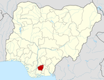
State Imo State LGA Oguta Population (2006) - Total 22,000 Time zone WAT (UTC+1) - Summer (DST) not observed (UTC) Postcode 464... Goddess Uhamiri Oguta is a city on the east bank of Oguta Lake in southeast Nigeria. Oguta was one of the first territories used by the British to advance into the Igbo hinterland. As of 2007 Oguta's population was estimated at 22,298. [1] It is divided into two townships separated by its popular lake: Oguta 1 and Oguta 2. Today, Oguta is better known for its resort hotel, challenging Scottish-designed golf course and home of commercial fishing. It has huge oil and Gas deposit known as the GOLDEN BELT.
Fish, yam and cassava are just some of the staples in an average Oguta person's diet.
Neighbouring towns include Izombe (an oil and gas settlement), Akri, Nkwesi, Nnebukwu, Orsu-Obodo, Egwe, and Egbuoma, border town with Anambra State.
Oguta 2 is home to Donguarella, an Italian Catholic outreach project for handicapped children.
See also
References
- ^ ""The World Gazetteer"". http://www.world-gazetteer.com/wg.php?men=gpro&des=gamelan&geo=344574683. Retrieved 2007-02-20.
Coordinates: 5°42′42″N 6°48′34″E / 5.71167°N 6.80944°E
 Imo State
State capital: Owerri LGAs Aboh Mbaise · Ahiazu Mbaise · Ehime Mbano · Ezinihitte · Ideato North · Ideato South · Ihitte/Uboma · Ikeduru · Isiala Mbano · Isu · Mbaitoli · Ngor Okpala · Njaba · Nkwerre · Nwangele · Obowo · Oguta · Ohaji/Egbema · Okigwe · Onuimo · Orlu · Orsu · Oru East · Oru West · Owerri Municipal · Owerri North · Owerri West ·
 Categories:
- Imo State geography stubs
- Populated places in Imo State
- Local Government Areas in Imo State
- Towns in Igboland
- Cities in Igboland
Wikimedia Foundation. 2010.

