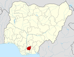
- Ngor Okpala
-
Ngor Okpala — LGA — Country  Nigeria
State Imo State Capital Time zone WAT (UTC+1) Ngor Okpala is a Local Government Area of Imo State, Nigeria. Its headquarters are in the town of Umuneke Ngor.
It has an area of 561 km² and a population of 159,932 at the 2006 census.Ngor-Okpala is notable place in Imo state because of her locational position. Ngor-Okpala connects Abia and Rivers states of Nigeria. Ngor-Okpala is the largest local government area in Imo State and one of the largest in Nigeria.
The postal code of the area is 460.[1] There are so many Communities in Ngor-Okpala. They include: Ntu, Alulu, Amala, Orburu, Obokwe, Eziama, Okpala, Ohekelem, Ihite, Obike, Elelem, Umuohiagu,Umuhu,Imerienwe, Nguru-Umuaro and many others. The most popular town in Ngor-Okpala is Nguru-umuaro(pronounced as ngwurru which has this statue by virture of its central location.Proximity to owerri the state capital(people from other parts of the local government going to owerri will have to get to nguru before boarding a vehicle to owerri),link roads to other parts of the local government. Ngor-Okpala is one of the fastest developing local governments in Imo State. Ngor-Okpala is blessed with natural and mineral resources which have not been tapped. I am Udodiri, a son of the soil and a native Amafor. Am very proud to be an Amaforian.
References
- ^ "Post Offices- with map of LGA". NIPOST. http://www.nipost.gov.ng/PostCode.aspx. Retrieved 2009-10-20.
 Imo StateState capital: Owerri
LGAs Aboh Mbaise · Ahiazu Mbaise · Ehime Mbano · Ezinihitte · Ideato North · Ideato South · Ihitte/Uboma · Ikeduru · Isiala Mbano · Isu · Mbaitoli · Ngor Okpala · Njaba · Nkwerre · Nwangele · Obowo · Oguta · Ohaji/Egbema · Okigwe · Onuimo · Orlu · Orsu · Oru East · Oru West · Owerri Municipal · Owerri North · Owerri West ·
 Categories:
- Local Government Areas in Imo State
- Imo State geography stubs
Wikimedia Foundation. 2010.
