- Orkney Tunnel
-
The Orkney Tunnel is a suggested undersea road tunnel between Orkney and Caithness on the Scottish Mainland. The expected length of it would be about 9-10 miles (15-16 km).
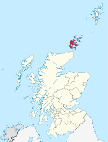 Orkney Islands in Scotland
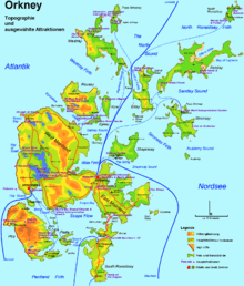 Map of Orkney showing topography and main transport routes
The tunnel, if constructed, is assumed to make landfall on South Ronaldsay. A total bill of £100 million is mentioned.[1][2]
There are also suggested plans to connect Orkney Mainland to Shapinsay.[3]
References
- ^ David Lister (5 September 2005). "Islanders see a brighter future with tunnel vision". The Times. http://www.timesonline.co.uk/article/0,,2-1765366,00.html. Retrieved 12 July 2007.
- ^ John Ross (10 March 2005). "£100m tunnel to Orkney 'feasible'". The Scotsman. http://thescotsman.scotsman.com/scotland/100m-tunnel-to-Orkney-feasible.2609387.jp. Retrieved 13 July 2007.
- ^ "Isle tunnel plans under spotlight". BBC News. 9 March 2005. http://news.bbc.co.uk/1/hi/scotland/4331889.stm. Retrieved 8 June 2009.
Orkney List of Orkney islands Inhabited Islands Mainland · Auskerry · Burray · Eday · Egilsay · Flotta · Gairsay · Graemsay · Hoy · North Ronaldsay · Papa Stronsay · Papa Westray · Rousay · Sanday · Shapinsay · South Ronaldsay · South Walls · Stronsay · Westray · WyreOther Islands Eynhallow · Helliar Holm · Lamb Holm · Switha · Swona · North West islands · North East islands · South West islands · South East islandsTowns and Villages Mainland Parishes Topics Categories:- Orkney
- Caithness
- Tunnels in Scotland
- Proposed undersea tunnels
- Northern Isles
- Tunnel stubs
- Orkney stubs


Wikimedia Foundation. 2010.