- Oriximiná
-
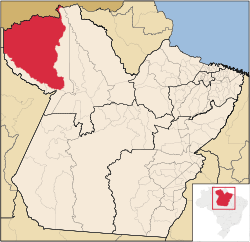
Oriximiná Location of Oriximiná Coordinates: 01°45′57″S 55°51′57″W / 1.76583°S 55.86583°WCoordinates: 01°45′57″S 55°51′57″W / 1.76583°S 55.86583°W Country Brazil Region Norte State Pará Founded June 13, 1877 Government – Mayor Luiz Gonzaga Viana Filho (PV) Area – Total 107,602.992 km2 (41,545.7 sq mi) Elevation 46 m (151 ft) Population (2008) – Total 57,765 – Density 0.5/km2 (1.3/sq mi) [1] HDI (2000) 0.717 – medium[2] Website www.oriximina.pa.gov.br Oriximiná is the westernmost and second largest city in the Brazilian state of Pará. The city lies on the Trombetas river, 40 km northwest of Óbidos. The city is crossed by the Equator.
Oriximiná is served by Oriximiná Airport located 8km from downtown Oriximiná. Porto Trombetas Airport located in the district of Porto Trombetas 70km away serves the population residing and working for the Mineração Rio do Norte S/A.
References
- ^ IBGE 2008 statistics
- ^ [1] - UNDP
Categories:- Populated places in Pará
- Populated places established in 1877
- Pará geography stubs
Wikimedia Foundation. 2010.

