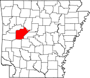
- Onyx, Arkansas
-
Onyx, Arkansas — Unincorporated community — Onyx's position in Arkansas. Coordinates: 34°51′5.3″N 93°24′28.7″W / 34.851472°N 93.407972°WCoordinates: 34°51′5.3″N 93°24′28.7″W / 34.851472°N 93.407972°W Country  United States
State  Arkansas
County Yell Township Crawford Elevation[1] 224 m (735 ft) Time zone Central (CST) (UTC-6) – Summer (DST) CDT (UTC-5) Area code(s) 479 GNIS feature ID 72854 U.S. Geological Survey Geographic Names Information System: Onyx, Arkansas Onyx is an unincorporated community in Crawford Township, Yell County, Arkansas, United States.[2] It is located where Arkansas Highway 314 begins at Arkansas Highway 27.[3]
References
- ^ "Onyx, Arkansas." Histopolis Retrieved October 13, 2011.
- ^ "Feature Detail Report for: Onyx, Arkansas." USGS. U.S. Geological Survey Geographic Names Information System: Onyx, Arkansas Retrieved October 13, 2011.
- ^ DeLorme. Arkansas Atlas and Gazetteer (Map) (Second ed.). Section 40.
Municipalities and communities of Yell County, Arkansas Cities Belleville | Danville | Dardanelle | Havana | Ola | Plainview
Town Unincorporated
communitiesAlpha | Aly | Bluffton | Briggsville | Centerville | Chickalah | Gravelly | Onyx | Rover | Sulphur Springs
Categories:- Arkansas geography stubs
- Populated places in Yell County, Arkansas
- Unincorporated communities in Arkansas
Wikimedia Foundation. 2010.


