- Oliveira do Bairro Municipality
-
Oliveira do Bairro — Municipality — 
Flag
Coat of armsLocation in Portugal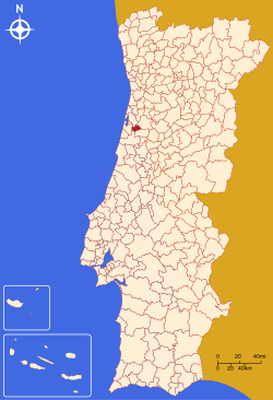
Coordinates: 40°31′N 8°30′W / 40.517°N 8.5°WCoordinates: 40°31′N 8°30′W / 40.517°N 8.5°W Country  Portugal
Region Centro Subregion Baixo Vouga District/A.R. Aveiro Government – Mayor Mário Oliveira (PSD) Area – Total 87.3 km2 (33.7 sq mi) Population – Total 22,012 – Density 256/km2 (663/sq mi) Parishes (no.) 6 Municipal holiday Ascension Day
date variesWebsite http://www.cm-olb.pt/ Oliveira do Bairro (Portuguese pronunciation: [oliˈvɐjɾɐ ðu ˈβajʁu]) is a municipality in Portugal with a total area of 87.3 km² and a total population of 22,012 inhabitants, and 16,994 electors (2006). The town itself has a population of 3,077.[1]
The municipality is composed of 6 parishes, and is located in the district of Aveiro. It is in the Bairrada area. The present Mayor is Mário João da Silva Oliveira, elected by the Social Democratic Party.
The municipal holiday is Ascension Day.
Contents
Demographics
Inhabitants (1801 – 2004) 1801 1849 1900 1930 1960 1981 1991 2001 2004 1939 5086 9540 14362 16699 17517 18660 21164 22365 Parishes
- Bustos
- Mamarrosa
- Oiã
- Oliveira do Bairro
- Palhaça
- Troviscal
References
- ^ UMA POPULAÇÃO QUE SE URBANIZA, Uma avaliação recente - Cidades, 2004 Nuno Pires Soares, Instituto Geográfico Português (Geographic Institute of Portugal)
External links
Ágeda · Albergaria-a-Velha · Anadia · Arouca · Aveiro · Castelo de Paiva · Espinho · Estarreja · Ílhavo · Mealhada · Murtosa · Oliveira de Azeméis · Oliveira do Bairro · Ovar · Santa Maria da Feira · São João da Madeira · Sever do Vouga · Vagos · Vale de Cambra Categories:
- Portugal geography stubs
- Municipalities of Portugal

Wikimedia Foundation. 2010.