Old Harbor Reservation Parkways

Old Harbor Reservation Parkways
Old Harbor Reservation Parkways, Metropolitan Park System of Greater Boston
Old Harbor Reservation Parkways is located in Massachusetts
Location: Boston, Massachusetts
Coordinates: 42°19′46″N 71°2′45″W / 42.32944°N 71.04583°W / 42.32944; -71.04583Coordinates: 42°19′46″N 71°2′45″W / 42.32944°N 71.04583°W / 42.32944; -71.04583
Area: 55.8 acres (22.6 ha)
Built: 1893
Architect: Frederick Law Olmstead
Arthur A. Schurcliff
Governing body: Local
MPS: Metropolitan Park System of Greater Boston MPS
NRHP Reference#:

08000693
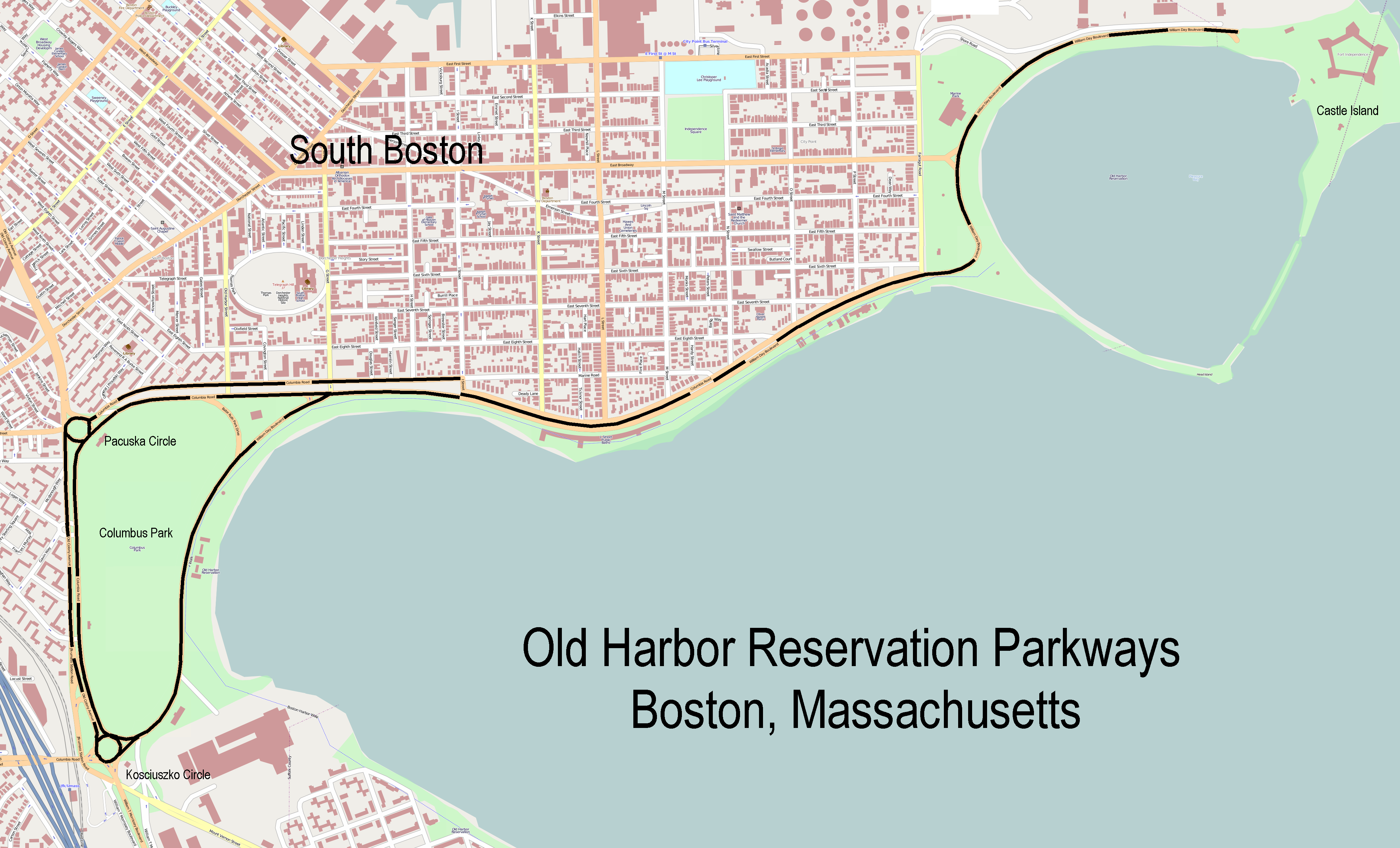
[1]
Added to NRHP: July 24, 2008

The Old Harbor Reservation Parkways are three historic roads in the Old Harbor area of Boston. They are part of the Boston parkway system designed by Frederick Law Olmstead. They include

  • all of William J. Day Boulevard from Castle Island to Kosciuszko Circle[2]
  • the part of Columbia Road from its northeastern end at Farragut Road to Kosciuszko Circle
  • the part of Old Colony Avenue from Sgt. Alexander F. Pacuska Circle[3] to its southern end near Kosciuszko Circle.

They were added to the National Register of Historic Places on July 24, 2008, reference number 08000693.

References

  1. ^ "National Register Information System". National Register of Historic Places. National Park Service. 2009-03-13. http://nrhp.focus.nps.gov/natreg/docs/All_Data.html. 
  2. ^ Statue in center of the circle, identified on some maps.
  3. ^ Plaque in the center of the circle, not identified on maps.


Wikimedia Foundation. 2010.

Игры ⚽ Нужно решить контрольную?

Look at other dictionaries:

  • Charles River Reservation — Charles River Basin Historic District U.S. National Register of Historic Places U.S. Historic district …   Wikipedia

  • Nahant Beach Reservation — Coordinates: 42°26′52″N 70°56′20″W / 42.44778°N 70.93889°W / 42.44778; 70.93889 …   Wikipedia

  • Dorchester Shores Reservation — Coordinates: 42°17′50″N 71°2′44″W / 42.29722°N 71.04556°W / 42.29722; 71.04556 …   Wikipedia

  • Chestnut Hill Reservation — Massachusetts State Park …   Wikipedia

  • Mystic River Reservation — The Mystic River Reservation is a publicly owned nature preserve located along the Mystic River in Massachusetts, United States. It forms part of the 75 square mile (190 km2) Mystic River Watershed, and runs through the towns of Arlington,… …   Wikipedia

  • National Register of Historic Places listings in Boston, Massachusetts — Location of Boston in Massachusetts This is a list of the National Register of Historic Places listings in Boston, Massachusetts. This is intended to be a complete list of the properties and districts on the National Register of Historic Places… …   Wikipedia

  • Department of Conservation and Recreation (Massachusetts) — MDCR redirects here. For the airport with that ICAO code, see Cabo Rojo Airport. Department of Conservation and Recreation Department overview Headquarters 251 Causeway Street, Boston Department executive Edward M. Lambert, Jr., Commissioner… …   Wikipedia

  • Cutler Park — Coordinates: 42°16′59″N 71°11′51″W / 42.28306°N 71.1975°W / 42.28306; 71.1975 …   Wikipedia

  • Morrissey Boulevard — William T. Morrissey Boulevard Morrissey Boulevard highlighted in red Maintained by: the Department of Conservation and Recreation Length …   Wikipedia

  • Roxbury Heritage State Park — Coordinates: 42°19′49″N 71°5′26″W / 42.33028°N 71.09056°W / 42.33028; 71.09056 …   Wikipedia

Share the article and excerpts

Direct link
Do a right-click on the link above
and select “Copy Link”