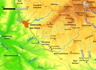
- Oder (Harz)
-
Oder Southwest Harz with the Oder
Data Location East Lower Saxony,  Germany
Length ca. 56 km Source near Oderbrück in the Harz Mountains Source height ca. 810 m above sea level Mouth near Katlenburg into the Rhume
51°40′44″N 10°6′11.05″E / 51.67889°N 10.1030694°EMouth height 131 m above sea level Descent ca. 679 m Basin Weser Progression Rhume → Leine → Aller → Weser → North Sea Catchment 385 km² Right tributaries Sperrlutter, Lutter, Sieber Left tributaries Pöhlder Beber Reservoirs passed Oderteich, Oder Reservoir Small towns Bad Lauterberg The Oder is a 56 km long river in Lower Saxony, Germany. It is a right tributary of the Rhume. Its source is in the Harz mountains, near Sankt Andreasberg. It flows southwest through Bad Lauterberg, Pöhlde and Hattorf am Harz. The Oder flows into the Rhume in Katlenburg-Lindau.
Villages where the river flows
- Oderbrück (district of Sankt Andreasberg)
- Oderhaus (district of Sankt Andreasberg)
- Bad Lauterberg
- Scharzfeld
- Pöhlde
- Hattorf am Harz
- Wulften am Harz
- Katlenburg-Lindau
Tributaries
- Sperrlutter
- Lutter
- Sieber
Pictures
-
The Oder above the Oderteich
-
Confluence of the Sperrlutter
-
The Oder in Bad Lauterberg
-
Confluence of Sieber (left) in the Oder (right) at Hattorf
-
The Oder in Wulften
Categories:- Leine drainage basin
- Rivers of Lower Saxony
- Rivers of the Harz
- Lower Saxony geography stubs
- Harz Mountain geography stubs
Wikimedia Foundation. 2010.


