- 2000 October subtropical storm
-
October 2000 Subtropical Storm Subtropical storm (SSHS) 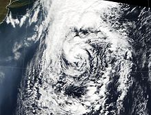
The Subtropical Storm on October 28 Formed October 25, 2000 Dissipated October 29, 2000 Highest winds 1-minute sustained:
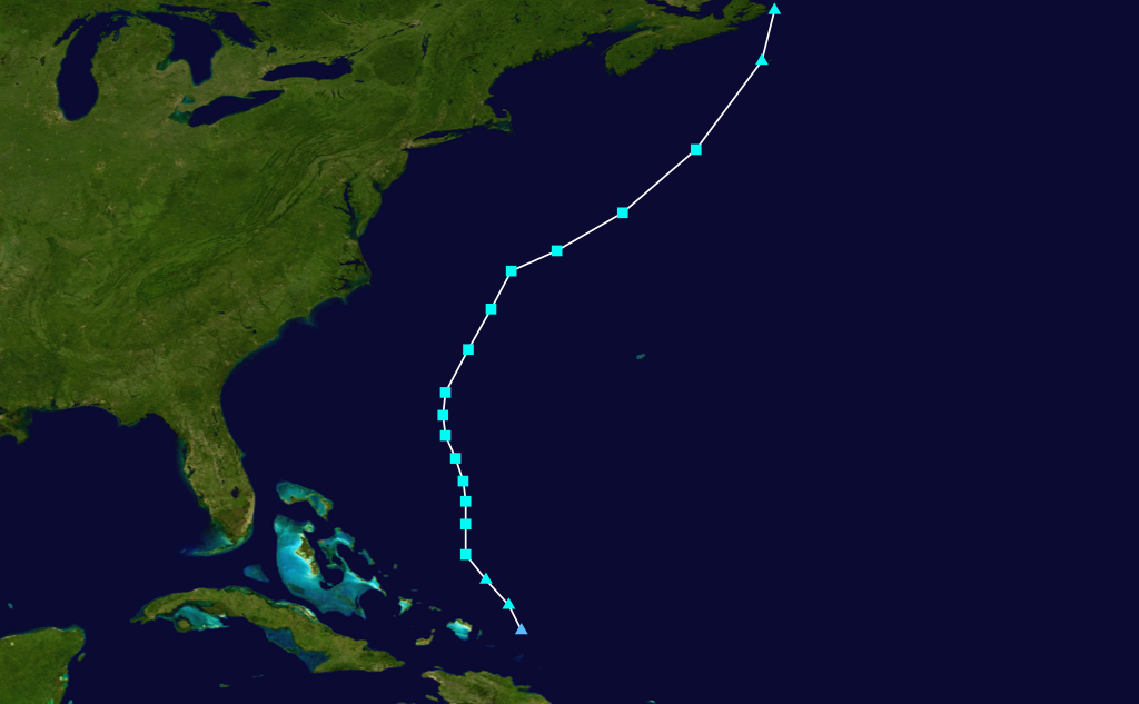
65 mph (100 km/h)Lowest pressure 976 mbar (hPa; 28.82 inHg) Fatalities None reported Damage $40,000 (2000 USD) Areas affected New Brunswick, Newfoundland and Labrador, Nova Scotia, and Prince Edward Island Part of the 2000 Atlantic hurricane season The Subtropical Storm of October 2000 was the final cyclone of the 2000 Atlantic hurricane season. The last cyclone of the season, the Subtropical Storm developed from an extratropical low pressure system in the vicinity of the Bahamas on October 25. It intensified gradually while heading generally northward, passing between roughly half way between Bermuda and North Carolina. Its maximum sustained winds were unknown during peak intensity, but it is estimated at 65 mph (105 km/h), though its minimum central pressure was 978 millibars (28.9 inHg). As a subtropical cyclone, it did not affect land, however, the remnants combined with an extratropical low, causing early heavy snowfall in Canada and in New England.
Contents
Meteorological History
 Storm path
On October 25, an extratropical low pressure system formed to the east of the Turks and Caicos Islands. Initially, the low moved northwestward and interacted with a strong surface high. Later that day, the low began to develop into a gale center. By 1800 UTC the gale center had become a subtropical storm. This subtropical storm began by turning in a northward motion. The subtropical storm had turned northward shortly before it made a north-north east turn and accelerated simultaneously. From then on the Subtropical Storm gradually strengthened and it began to turn on a more northeastward course.[1]
By October 27 it had acquired an intensity of 60 mph (97 km/h). Convection flared up on October 28, which allow it to reached a peak intensity of 65 mph (105 km/h), and a minimum pressure of 978 millibars (28.9 inHg). A cold front linked up with the Subtropical Storm to become extratropical, a few hundred miles to the south of Halifax, Nova Scotia. That same day, the system merged with a larger extratropical low. The extratropical low eventually reached Atlantic Canada, before it lost its identity later that day near eastern Nova Scotia.[1]
Impact
The Marine Prediction Center issued some marine gale and storm warnings offshore, while the National Weather Service issued gale warnings for coastal North Carolina. There were no other watch or warnings issued because it was treated as an extratropical cyclone.[1]
The larger extratropical low in which the remnants merged with headed for Atlantic Canada and it caused heavy snowfall over portions of southeastern Canada, and even in some New England states. On October 29, several stations in Nova Scotia and Newfoundland reported sustained winds between 40 - 58 miles per hour (64 - 93 km/h) and an atmospheric pressure of 980 millibars (hPa; 28.94 inHg) was recorded on Sable Island.[1] Maximum sustained winds in Atlantic Canada reached 44 miles per hour (72 km/h), while gusts were reported at 52 miles per hour (84 km/h) in Cape Breton Highlands. Wave heights reached 39 feet (12 m) in the Gulf of St. Lawrence, with storm surge in New Brunswick and Prince Edward Island near five feet (1.9 m), which resulted in extensive coastal flooding.[2]
Many ships and buoys that encountered the subtropical storm reported winds greater than 40 miles per hour (65 km/h). Almost all of the ships reported barometric pressures greater than 990 millibars (hPa; 29.23 inHg), although the Buoy 44137 recorded a pressure as low as 979 millibars (hPa; 28.91 inHg) early on October 29, whilst a ship thereafter registered 985 millibars (hPa; 29.09 inHg). In addition, the ship "Nomzi" reported the highest maximum sustained winds of 53 miles per hour (85 km/h).[1]
There is a slight possibility of the maximum sustained winds being inaccurate, the forward motion of the subtropical storm caused possibilities of sustained winds as high as 85 miles per hour (135 km/h). However, surface observations did not support this, instead it was estimate that maximum sustained winds were 65 miles per hour (100 km/h).[1]
This was the last time that a subtropical storm did not receive a name because between 1974 and 2000 the National Hurricane Center did not name purely subtropical storms. If it were to receive a name it would be Oscar and therefore Subtropical Storm Oscar.[1]
See also
- 2000 Atlantic hurricane season
- Subtropical cyclone
- Extratropical cyclone
- Timeline of the 2000 Atlantic hurricane season
Reference
- ^ a b c d e f g Beven, Jack (November 27, 2000). "Subtropical Storm Tropical Cyclone Report". National Hurricane Center. http://www.nhc.noaa.gov/2000subtropical.html. Retrieved December 19, 2009.
- ^ Bowyer, Peter (July 9, 2009). "Canadian Tropical Cyclone Season Summary for 2000". Environment Canada. http://www.ec.gc.ca/ouragans-hurricanes/default.asp?lang=en&n=9805D6F1-1. Retrieved 27 September 2010.
External links
Categories:- 2000 Atlantic hurricane season
- Subtropical storms

Wikimedia Foundation. 2010.