- Obozersky
-
Obozersky (English)
Обозерский (Russian)- Urban-type settlement[1] - 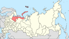
Location of Arkhangelsk Oblast in Russia
 Obozersky
Coordinates: 63°26′N 40°18′E / 63.433°N 40.3°ECoordinates: 63°26′N 40°18′E / 63.433°N 40.3°E Administrative status Country Russia Federal subject Arkhangelsk Oblast Administrative district Plesetsky District[1] Municipal status (as of July 2011) Municipal district Plesetsky Municipal District[2] Urban settlement Obozerskoye Urban Settlement[2] Administrative center of Obozerskoye Urban Settlement[2] Statistics Population (2010 Census,
preliminary)3,619 inhabitants[3] Population (2002 Census) 3,725 inhabitants[4] Time zone MSD (UTC+04:00)[5] Founded 1957[6] Postal code(s) 164251, 164254, 164255[7] Obozersky (Russian: Обозерский) is an urban locality (an urban-type settlement) in Plesetsky District of Arkhangelsk Oblast, Russia, located on the upper Vaymuga River, a triburaty of the Yemtsa River in the Northern Dvina basin. Obozersky lies 133 kilometers (83 mi) south of Arkhangelsk (by rail). The name of the settlement originates from Lake Obozero, located south of Obozersky. Military airfield Letneozyorsk is located 3 kilometers (1.9 mi) southeast of the settlement. Municipally, Obozersky is the administrative center of Obozerskoye Urban Settlement, one of the eight urban settlements in the district. Population: 3,619 (2010 Census preliminary results);[3] 3,725 (2002 Census);[4] 5,837 (1989 Census).[8].
Contents
History
Obozyorsky was established as a railway station on November 29, 1987, when the railway stretch between Vologda and Arkhangelsk was built. Previously, the village of Alexandrovskaya existed at the same location. Alexandrovskaya was known from the mid-19th century.[9] Obozyorskaya was one of the biggest cargo stations of the railway. From 1922, the station was included into Yakovlevskaya Volost of Arkhangelsky Uyezd, Arkhangelsk Governorate. In 1926, it was transferred to Plesetskaya Volost. On July 15, 1929, the uyezds were abolished, the governorates merged into Northern Krai, and Plesetsky District was established.[10] In 1937, the settlement at Obozyorskaya railway station became the administrative center of Yakovlevsky Selsoviet.
The urban-type settlement of Obozersky was established by the Decree of the Presidium of the Russian SFSR Supreme Soviet on September 12, 1957. Yakovlevsky Selsoviet was transferred to Obozersky Settlement Soviet.[6]
Economy
The economy of Obozersky is based on lime production, logging and timber.
Obozerskaya Railway station is a part of the Northern Railway. The main railroad here connects Moscow and Arkhangelsk, and another railroad to Onega, Belomorsk and Murmansk branches off to the west. This railroad was built during World War II to secure the transport of goods from the harbor of Murmansk to central Russia.
Obozersky is located on the road connecting Kargopol with one of the principal highways in Russia, M8 between Moscow and Arkhangelsk (the highways meet in the village of Brin-Navolok). This is the historic trading route which connected Kargopol with Arkhangelsk before the railroad was built, and long stretches of this road are still unpaved.
Culture and recreation
There is the Chapel of the Tikhvin Icon of the Virgin in Obozersky, built in the late 1990s.
References
Notes
- ^ a b Государственный комитет Российской Федерации по статистике. Комитет Российской Федерации по стандартизации, метрологии и сертификации. №ОК 019-95 1 января 1997 г «Общероссийский классификатор объектов административно-территориального деления. Код 11 250 563 004», в ред. изменения №168/2011 от 1 октября 2011 г. (State Statistics Committee of the Russian Federation. Committee of the Russian Federation on Standardization, Metrology, and Certification. #OK 019-95 January 1, 1997 Russian Classification of Objects of Administrative Division . Code 11 250 563 004, as amended by the Amendment #168/2010 of October 1, 2011. ).
- ^ a b c Архангельское областное Собрание депутатов. Областной закон №258-внеоч.-ОЗ от 23 сентября 2004 г. «О статусе и границах территорий муниципальных образований в Архангельской области (текст в ред. от 15 февраля 2010 г.)», в ред. Областного закона №309-23-ОЗ от 7 июля 2011 г «О внесении изменений и дополнений в отдельные Областные законы в сфере организации и осуществления местного самоуправления». Вступил в силу со дня официального опубликования. Опубликован: "Волна", №38, 8 октября 2004 г. (Arkhangelsk Oblast Council of Deputies. Oblast Law #258-vneoch.-OZ of September 23, 2004 On the Status and Borders of the Territories of the Municipal Formations in Arkhangelsk Oblast (text of rev. of February 15, 2010), as amended by the Oblast Law #309-23-OZ of July 7, 2011 On Amending and Supplementing Several Oblast Laws on the Subject of Organization and Implementation of the Local Self-Government. Effective as of the day of the official publication).
- ^ a b Федеральная служба государственной статистики (Federal State Statistics Service) (2011). "Предварительные итоги Всероссийской переписи населения 2010 года (Preliminary results of the 2010 All-Russian Population Census)" (in Russian). Всероссийская перепись населения 2010 года (All-Russia Population Census of 2010). Federal State Statistics Service. http://www.perepis-2010.ru/results_of_the_census/results-inform.php. Retrieved 2011-04-25.
- ^ a b Федеральная служба государственной статистики (Federal State Statistics Service) (2004-05-21). "Численность населения России, субъектов Российской Федерации в составе федеральных округов, районов, городских поселений, сельских населённых пунктов – районных центров и сельских населённых пунктов с населением 3 тысячи и более человек (Population of Russia, its federal districts, federal subjects, districts, urban localities, rural localities—administrative centers, and rural localities with population of over 3,000)" (in Russian). Всероссийская перепись населения 2002 года (All-Russia Population Census of 2002). Federal State Statistics Service. http://www.perepis2002.ru/ct/doc/1_TOM_01_04.xls. Retrieved 2010-03-23.
- ^ Правительство Российской Федерации. Постановление №725 от 31 августа 2011 г. «О составе территорий, образующих каждую часовую зону, и порядке исчисления времени в часовых зонах, а также о признании утратившими силу отдельных Постановлений Правительства Российской Федерации». Вступил в силу по истечении 7 дней после дня официального опубликования. Опубликован: "Российская Газета", №197, 6 сентября 2011 г. (Government of the Russian Federation. Resolution #725 of August 31, 2011 On the Composition of the Territories Included into Each Time Zone and on the Procedures of Timekeeping in the Time Zones, as Well as on Abrogation of Several Resolutions of the Government of the Russian Federation. Effective as of after 7 days following the day of the official publication).
- ^ a b "Краткая историческая справка Плесецкого района" (in Russian). МО "Плесецкий район". http://www.moples.ru/index.php?id=4. Retrieved 3 August 2011.
- ^ "List of postal codes" (in Russian). Russian Post. http://info.russianpost.ru/database/ops.html. Retrieved 3 August 2011.
- ^ "Всесоюзная перепись населения 1989 г. Численность наличного населения союзных и автономных республик, автономных областей и округов, краёв, областей, районов, городских поселений и сёл-райцентров. (All Union Population Census of 1989. Present population of union and autonomous republics, autonomous oblasts and okrugs, krais, oblasts, districts, urban settlements, and villages serving as district administrative centers.)" (in Russian). Всесоюзная перепись населения 1989 года (All-Union Population Census of 1989). Demoscope Weekly (website of the Institute of Demographics of the State University—Higher School of Economics. 1989. http://demoscope.ru/weekly/ssp/rus89_reg.php. Retrieved 2010-03-23.
- ^ "МО "Обозерское"" (in Russian). МО "Плесецкий район". http://www.moples.ru/index.php?id=28. Retrieved 10 August 2011.
- ^ "Постановление Президиума ВЦИК от 15 июля 1929 года о составе округов и районов Северного Края и их центрах" (in Russian). consultant.ru. http://base.consultant.ru/cons/cgi/online.cgi?req=doc;base=ESU;n=15910. Retrieved 12 June 2011.
Sources
- Архангельское областное Собрание депутатов. Областной закон №65-5-ОЗ от 23 сентября 2009 г. «Об административно-территориальном устройстве Архангельской области», в ред. Областного закона №150-12-ОЗ от 4 мая 2010 г «О внесении изменений и дополнений в отдельные областные законы». Вступил в силу через десять дней со дня официального опубликования. Опубликован: "Волна", №43, 6 октября 2009 г. (Arkhangelsk Oblast Council of Deputies. Oblast Law #65-5-OZ of September 23, 2009 On the Administrative and Territorial Structure of Arkhangelsk Oblast, as amended by the Oblast Law #150-12-OZ of May 4, 2010 On Amending and Supplementing Certain Oblast Laws. Effective as of the day ten days after the official publication).
Categories:- Urban-type settlements in Arkhangelsk Oblast

Wikimedia Foundation. 2010.