Nyainqêntanglha Mountains

Nyainqêntanglha Mountains
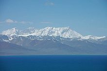
The Nyainqên Tanglha Mountains above the Namtso Lake
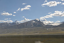
The Nyainqên Tanglha Mountains Viewed from Qingzang Railway

Nyenchen Tanglha or Nyainqêntanglha (Tibetan: གཉན་ཆེན་ཐང་ལྷ་Wylie: Gnyan-chen-thang-lha; Chinese: 念青唐古拉山, Pinyin: Niànqīng Tánggǔlā Shān) is a mountain range lying approximately 300 kilometer north-west of Lhasa in central Tibet.

The range's highest peak, Mount Nyainqêntanglha, stands at 7,162 metres in Damxung County; the nearest town to this peak is Yangbajain. The mountain range has more than thirty peaks over 6,000 metres high, and four are more than 7,000 metres high.

The Nyainqên Tanglha range separates the basin of the Yarlung Tsangpo River (Brahmaputra) in the south from the endorheic basins of north-eastern Tibet in the north. In particular, it lies to the south of Namtso Lake (Tengrinor), the second largest saltwater lake in Tibet; it is said to be the highest saline lake in the world at 4,716 metres (15,472 ft). Extending into the center of the lake is Zaxi Peninsula with its Zaxi Temple.

Coordinates: 30°19′0″N 90°7′50″E / 30.316667°N 90.13056°E / 30.316667; 90.13056


Wikimedia Foundation. 2010.

Игры ⚽ Поможем написать курсовую

Look at other dictionaries:

  • Nyainqêntanglha Mountains — ▪ mountains, China Chinese (Pinyin)  Nianchingtanggula Shan  or  (Wade Giles romanization)  Nien ch ing t ang ku la Shan        mountain range forming the eastern section of a mountain system in the southern part of the Tibet Autonomous Region,… …   Universalium

  • Nyainqêntanglha Peak — Mount Nyainqêntanglha Elevation 7,162 m (23,497 ft) [1 …   Wikipedia

  • Tanggula Mountains — viewed from Qinghai Tanggula Mountains …   Wikipedia

  • Гандисышань — Гандисышань …   Википедия

  • Mainling County — Mainling Zong   County   Tibetan transcription(s)  – Tibetan སྨན་གླིང་རྫོང་།   …   Wikipedia

  • Geography of China — Topography of China. Longsheng Rice Terrac …   Wikipedia

  • Himalayas — Himalayan, adj. /him euh lay euhz, hi mahl yeuhz/, n. the, a mountain range extending about 1500 mi. (2400 km) along the border between India and Tibet. Highest peak, Mt. Everest, 29,028 ft. (8848 m). Also called the Himalaya, Himalaya Mountains …   Universalium

  • Lhasa — For other uses, see Lhasa (disambiguation). This article is about the urban area of Lhasa. See Lhasa Prefecture for the wider prefecture Lhasa 拉萨 ལྷ་ས་ Lasa   Prefecture level city   …   Wikipedia

  • Damxung County —   County   Tibetan transcription(s)    Tibetan འདམ་གཞུང་རྫོང།    Wylie transliteration ’dam gzhung rdzong     …   Wikipedia

  • Ньенчен-Тангла — Координаты: …   Википедия

Share the article and excerpts

Direct link
Do a right-click on the link above
and select “Copy Link”