- Novoazovsk Raion
-
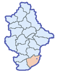
Novoazovsk Raion
Новоазовський район— Raion — 
Flag
Coat of armsLocation of Novoazovsk Raion in Urkaine
Country  Ukraine
Oblast Donetsk Oblast Established N/A Admin. center Novoazovsk Government - Governor N/A Area - Total 1,000 km2 (386.1 sq mi) Population - Total 38,861 - Density 38.9/km2 (100.6/sq mi) Time zone EET (UTC+2) - Summer (DST) EEST (UTC+3) Postal index 876-XX Area code 380- Website Novoazovskiy raion portal The Novoazovsk Raion (Ukrainian: Новоазовський район, translit.: Novoazovs'kyi raion; Russian: Новоазовский район, translit.: Novoazovskiy raion) is a raion (district) within the southern portion of Donetsk Oblast in eastern Ukraine. Its administrative center is Novoazovsk, population is 38,861, and its area is 1,000 km². The raion's southern portion borders the Azov Sea.
Within the Novoazovs'kyi Raion there are: one city (Novoazovsk), 1 urban-type settlement (Sedovo), 9 selsovets, and 59 settlements. Also included within the raion are: 14 industrial organizations, 4 construction and transport organizations, 9 kolhozy, 5 sovhozy, 3 rybkolhozy, 5 industrial organizations, 4 construction companies, 35 medical schools, 27 resort areas, and 26 libraries.
Contents
History

Until 1920, the territory of the Novoazovs'kyi Raion was included in the Voyska Donskogo Oblast' of the Russian Empire. In April of the same year, the territory, then located within the Taganrogskiy Raion, was ceded to the newly organaized Donetsk Governorate.
In the beginning of 1923, the Novo-Nikolaevskiy Raion was organized. On September 22, 1923, the administrative center of the then Novo-Nikolaevskiy Raion, Novo-Nikolaevka, was renamed into Budennovka, and the Novo-Nikolaevskiy Raion - into Budennovskiy Raion.
In 1958, the Budennovskiy Raion was renamed into the Novoazovskiy Raion, and its administrative center - into Novoazovsk.
Within the Novoazovskyi Raion, were born the: Arctic explorer Georgy Sedov, the general-polkovnik Hero of the Soviet Union I. Lyudnikov, poet N. Scherbina, and the sculptor N. Yasinenko.
Environment
- The nature preserve Khomytovs'ka steppe or Khomutovskyy steppe[1] (Ukrainian: Хомуто́вський степ, Russian: Хомутовская степь), part of the Ukrainian steppe National Park, is a nature preserve located within the oblast'. Having an area is 10.28 km², the preserve consists of many different types of flora. It is currently listed in the UNESCO list of natural monuments.
- The regional park Meotyda (Ukrainian: Меотида, Russian: Меотида) is a natural park with a total area of 130.17 km². The park contains over 640 different types of rare and unique flora, 15 of which are listed in the Ukraine's Red Book of Rare Species.
Settlements
- Siedove (Ukrainian: Сєдове; Russian: Седово; formerly: Kryva Kosa) is an urban-type settlements (townlet) with a population of 2,770. Formerly a kolhoz by the name of Zavet Il'icha, the urban-type settlement now consists of the Kholodne and Obryv settlements.
- Bezimenne (Ukrainian: Безіменне; Russian: Безыменное; literally: No-name) is a village (selo) with a population of 2,529. It was formerly known as the Druzhba Narodiv kolhoz. The village now consists of the following settlements: Vedens'ke, Vesele, Kachkars'ke, Mitkogo-Kacharki, Pavlovs'ke, Patriotychne, and Roza.
- Vynohradne (Ukrainian: Виноградне; Russian: Виноградное) is a village (selo) with a population of 1,856. Formerly known as the Rodyna kolhoz, it now consists of the Pioners'ke, Prymors'ke, and Kalynovka settlements.
- Kominternove (Ukrainian: Комінтернове; Russian: Коминтерново) is a village (selo) with a population of 494. It is formerly known as the Ohorodnyi kolhoz. The village now consists of the Dzerzhyns'ke, Zaichenko, Leninske, Nova Tavria, and Novobydogo settlements.
- Krasnoarmiis'ke (Ukrainian: Красноармійське; Russian: Красноармейское) is a village (selo) with a population of 1,191. Formerly known as the Zaria Komunyzna kolhoz, the village now consists of the Kozats'ke, Kulykogo, Oktyabr, Porokhnia, and Shevchenko settlements.
- Pavlopil' (Russian: Павлопіль; Russian: Павлополь) is a village (selo) with a population of 615. Formerly known as the Avantgarde kolhoz, it now consists of the Pyschevyk and Chernenko settlements.
- Prymors'ke (Ukrainian: Приморське; Russian: Приморское) is a village (selo) with a population of 1,495. It was formerly known as the Prymors'kyi kolhoz. The village now consists of the Naverezhne, Sosnovs'ke, Pervomais'ke, and Ukrains'ke settlements.
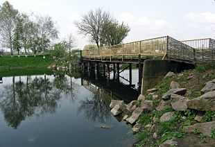 A wooden bridge leads to the entrance to the Khomytovs'ka steppe natural preserve.
- Samilove (Ukrainian: Самійлове; Russian: Самойлово) is a village (selo) with a population of 536. Formerly known as the Mayak kolhoz, the village now consists of the Klynykyno, Vanuashkyno, Kovs'ke, Kuznetsy, Markyno, Peremozhne, and Scherbak settlements.
- Khomutove (Ukrainian: Хомутове; Russian: Хомутово) is a village (selo) with a population of 760. It was formerly known as the kolhoz by the name of Lenin. The village now consists of the following settlements: Bessarabka, Vytava, Rozy Liuksemburh, and Sedogo-Vasyl'evla.
- Shyrokyne (Ukrainian: Широкине; Russian: Широкино) is a settlement with a population of 1,347. Formerly known as the kolhoz by the name of 21st Convention of the CPSU, the settlement now consists of the following settlements: Berdians'ke, Lebedyns'ke, Sakhanka, and Sopyno.
See also
- Subdivisions of Ukraine
- Donetsk Oblast
References
- ^ See also: (Russian) geocaching.su - Khomytovs'ka steppe website
External links
- (Ukrainian) Verkhovna Rada website - Administrative divisions of the Amvrosiivsky Raion
- (Russian) novoazovsk.net - Novoazovskiy raion portal
- (Russian) info.dn.ua - Information about the raion
Categories:- Raions of Donetsk Oblast


Wikimedia Foundation. 2010.