- Norton, West Virginia
-
Norton, West Virginia — Unincorporated community — 
 Norton, West Virginia
Coordinates: 38°55′54″N 79°57′56″W / 38.93167°N 79.96556°WCoordinates: 38°55′54″N 79°57′56″W / 38.93167°N 79.96556°W Country United States State West Virginia County Randolph Elevation 1,982 ft (604 m) Time zone Eastern (EST) (UTC-5) – Summer (DST) EDT (UTC-4) ZIP code 26285 Area code(s) 304 & 681 GNIS feature ID 1544239[1] Norton is an unincorporated community in Randolph County, West Virginia, United States. Norton is 6.5 miles (10.5 km) west of Elkins, at the junction of County Route 151 and Corridor H. Norton has a post office with ZIP code 26285.[2] The town was built as a company town for a nearby coal mine operated by the West Virginia Coal and Coke Company from the early 1900's until the late 1950's. Besides the mine, the town was once home to a company store, a company bank, and the Norton Grade School. The denominationally unaffiliated Norton Community Church still serves the town.
References
- ^ "US Board on Geographic Names". United States Geological Survey. 2007-10-25. http://geonames.usgs.gov. Retrieved 2008-01-31.
- ^ ZIP Code Lookup
Municipalities and communities of Randolph County, West Virginia City 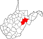
Towns CDPs Bowden | Dailey | East Dailey | Helvetia | Pickens | Valley Bend | Valley Head
Unincorporated
communitiesAdolph | Bemis | Canfield | Cassity | Cheat Bridge | Czar | Dryfork | Elkwater | Ellamore‡ | Fairview (near Elkins) | Fairview (near Helvetia) | Glady | Hazelwood | Jimtown | Job | Kerens | Mabie | Mingo | Monterville | Norton | Osceola | Sullivan | Upper Mingo | Whitmer | Wymer
Footnotes ‡This populated place also has portions in an adjacent county or counties
Categories:- Populated places in Randolph County, West Virginia
- Unincorporated communities in West Virginia
- Potomac Highlands geography stubs


Wikimedia Foundation. 2010.