- Mingo, West Virginia
-
Mingo, West Virginia — Unincorporated community — 
 Mingo, West Virginia
Coordinates: 38°29′55″N 80°03′15″W / 38.49861°N 80.05417°WCoordinates: 38°29′55″N 80°03′15″W / 38.49861°N 80.05417°W Country United States State West Virginia County Randolph Elevation 2,644 ft (806 m) Time zone Eastern (EST) (UTC-5) - Summer (DST) EDT (UTC-4) Area code(s) 304 & 681 GNIS feature ID 1552161[1] Mingo — sometimes known as Mingo Flats — is an unincorporated community in Randolph County, West Virginia, USA. It is located on U.S. Route 219 15.5 miles (24.9 km) south-southwest of Huttonsville. It is named for the historic Iroquoian Mingo people.
References
- ^ "US Board on Geographic Names". United States Geological Survey. 2007-10-25. http://geonames.usgs.gov. Retrieved 2008-01-31.
Municipalities and communities of Randolph County, West Virginia County seat: Elkins City 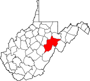
Towns CDPs Bowden | Dailey | East Dailey | Helvetia | Pickens | Valley Bend | Valley Head
Unincorporated
communitiesAdolph | Bemis | Canfield | Cassity | Cheat Bridge | Czar | Dryfork | Elkwater | Ellamore‡ | Fairview (near Elkins) | Fairview (near Helvetia) | Glady | Hazelwood | Jimtown | Job | Kerens | Mabie | Mingo | Monterville | Norton | Osceola | Sullivan | Upper Mingo | Whitmer | Wymer
Footnotes ‡This populated place also has portions in an adjacent county or counties
Categories:- Populated places in Randolph County, West Virginia
- Unincorporated communities in West Virginia
- Potomac Highlands geography stubs


Wikimedia Foundation. 2010.