- North Forty Foot Bank
-
Coordinates: 53°00′44″N 0°08′19″W / 53.0121500°N 0.1385572°W
North Forty Foot Bank 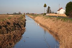
North Forty Foot Drain
 North Forty Foot Bank
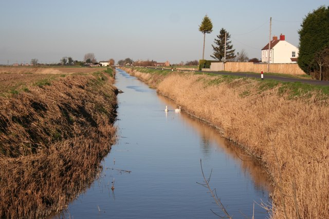
North Forty Foot Bank shown within LincolnshireOS grid reference TF249477 Parish Holland Fen with Brothertoft District Boston (borough) Shire county Lincolnshire Region East Midlands Country England Sovereign state United Kingdom Post town Boston Postcode district PE20 Dialling code 01205 Police Lincolnshire Fire Lincolnshire Ambulance East Midlands EU Parliament East Midlands UK Parliament Boston and Skegness List of places: UK • England • Lincolnshire The North Forty Foot Bank is a settlement which runs about six miles alongside the North Forty Foot Drain, about five to nine miles north west of Boston Lincolnshire, England. It begins just below the parish of Chapel Hill and runs along the drain to Toft Tunnel, just north of Hubberts Bridge. Despite its length, it only consists of the area on the north side of the drain, which was built in 1720 by Earl Fitzwilliam.[1] The North Forty Foot Bank forms the boundary between Harts Grounds and Pelhams Lands.
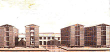 Major Cartwrights Woad Mill
A row of 29 brick and slate cottages were built between the North Forty Foot Bank and the hamlet of Brothertoft by Major John Cartwright to accommodate the workers of his red brick woad mill in the late 18th century. This place was then called Isatica which is latin for woad.[2] After Cartwright left Brothertoft for London, the hamlet of Isatica fell into ruin and disappeared.[3] [4]
Formerly extra-parochial, the North Forty Foot Bank was created a civil parish in 1858, but in 1906 became part of the civil parish of Holland Fen with Brothertoft.[5]
Settlements within North Forty Foot Bank include:
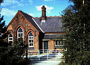 Hedgehog Bridge School
Hedgehog Bridge which lies about 5 miles (8.0 km) north west of Boston, Lincolnshire, on the North Forty Foot Bank. It was named after a bridge across the North Forty Foot Drain, which had a metal frame with spikes resembling a hedgehog. Hedgehog Bridge School was built in 1880 by the North-East Holland Fen School Board for 95 children.[6] It opened on 4th April 1881, became a Council School in 1903, and a County School about 1947. It finally closed in December 1969, and was demolished in 2010.[7] [8] [9] [10]
Toft Tunnel lies at the junction of the North Forty Foot Bank and the B1192 Langrick Road. It consists today mainly of farms. [11]
References
- ^ W. H. Wheeler (1868). "History Of The Fens Of South Lincolnshire". p. 44. http://babel.hathitrust.org/cgi/ptsearch?id=loc.ark%3A%2F13960%2Ft1xd1dh90;q1=%22north%20forty%20foot%22. Retrieved 6 May 2011.
- ^ T. W. Bearstall (1978). Maurice Barley. ed. Agricultural Revolution in Lincolnshire. The History of Lincolnshire Committee. p. 222. ISBN 0902668072.
- ^ Arthur Young (1799). "General View of the Agriculture of the County of Lincoln". Board of Agriculture. p. 35. http://books.google.co.uk/books?id=nw4AAAAAQAAJ&pg=PA35&dq=cartwright+brothertoft+cottages&hl=en&ei=AsrDTa37EY-t8QOUpLnGAw&sa=X&oi=book_result&ct=result&resnum=3&ved=0CF8Q6AEwAg#v=onepage&q=cartwright%20brothertoft%20cottages&f=false. Retrieved 6 May 2011.
- ^ "Lincs To The Past". Lincolnshire Archives/English Heritage. http://www.lincstothepast.com/Dispersed-settlement-of-Brothertoft/242687.record?pt=S. Retrieved 6 May 2011.
- ^ "Vision Of Britain". University of Portsmouth. http://www.visionofbritain.org.uk/relationships.jsp?u_id=10445310&c_id=10001043. Retrieved 2 May 2011.
- ^ "Kellys Directory 1919". Kellys Directories Ltd. p. 294. http://www.historicaldirectories.org/hd/d.asp. Retrieved April 20, 2011.
- ^ "Lincs to the Past". Ref name SR/o83. Lincolnshire Archives. http://www.lincstothepast.com/BROTHERTOFT-HEDGEHOG-BRIDGE-COUNTY-PRIMARY-SCHOOL/824869.record?pt=S. Retrieved 5 May 2011.
- ^ [1]
- ^ [2]
- ^ [3]
- ^ "Google Map". Google. http://maps.google.co.uk/maps?hl=en&rlz=&q=toft+tunnel+holland+fen&um=1&ie=UTF-8&hq=&hnear=Toft+Tunnel,+Swineshead&gl=uk&ei=W-m-TfKqMsG38QO2wrzdBQ&sa=X&oi=geocode_result&ct=image&resnum=1&ved=0CBkQ8gEwAA. Retrieved 2 May 2011.
Categories:- Lincolnshire geography stubs
- Villages in Lincolnshire


Wikimedia Foundation. 2010.