- North Fork Flathead River
-
North Fork Flathead River North Fork of Flathead River, North Fork of the Flathead River River 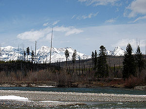 The river at the boundary of Glacier National Park
Countries Canada, United States States British Columbia, Montana City West Glacier, Montana Source Clark Range - coordinates 49°19′56″N 114°51′09″W / 49.33222°N 114.8525°W [1] Mouth Flathead River - elevation 3,120 ft (951 m) - coordinates 48°28′02″N 114°04′09″W / 48.46722°N 114.06917°W [1] Length 153 mi (246 km) [2] Basin 1,560 sq mi (4,040 km2) Discharge for USGS gage #1235550, 4.1 miles (6.6 km) from the mouth - average 2,976 cu ft/s (84 m3/s) - max 69,100 cu ft/s (1,957 m3/s) - min 190 cu ft/s (5 m3/s) 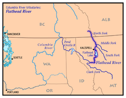 Map of the Flathead River drainage basin showing the North Fork
The North Fork Flathead River is a 153-mile (246 km)[2] river flowing through British Columbia (BC), Canada south into the U.S. state of Montana. It is one of the three primary forks of the Flathead River, a tributary of the Pend Oreille River, via Clark Fork. The river is sometimes considered the upper headwaters of the Flathead River,[3] although the North Fork is its official name in the U.S. Other naming conventions for the river include Flathead River - North Fork, North Fork of Flathead River, and North Fork of the Flathead River.[1]
The river originates in a valley northeast of Lake Koocanusa in the Clark Range, and flows west. It then meets the Continental Divide and turns south, winding through a broad glacial valley. The river then crosses the U.S.-Canada border into the state of Montana, where it begins to delineate the western boundary of Glacier National Park. Roughly following Montana State Route 486, the river winds southwest past Kintla Lake, Bowman Lake, Quartz Lake, Logging Lake, and Lake McDonald, then turns west and south into a narrower valley before joining the Middle Fork Flathead River near the southwestern entrance of the national park, several miles northeast of Columbia Falls. Less than 6 miles (9.7 km) below this confluence, the combined river joins the South Fork Flathead River, forming the main Flathead River.[4]
Contents
Wild and Scenic River designation
Although the North Fork is designated as a National Wild and Scenic River (1975) in the United States, its greater length in BC (31 miles (50 km), not including headwaters forks) is not. Water in the BC section remains relatively pure as there are no permanent residents or livestock in this drainage north of the border.[5]
Dam proposal
In the 1940s the Glacier View Dam was proposed, which would have flooded much of the river's valley between Glacier View Mountain and the Canadian border. Supported by Flathead Valley interests, the dam and reservoir were opposed by the National Park Service, as between 10,000 acres (4,000 ha) and 20,000 acres (8,100 ha) of park lands would have been flooded. The proposed dam was cancelled by 1950.[6]
See also
- Hungry Horse Reservoir
- List of rivers of Montana
References
49°11′44″N 114°30′39″W / 49.1956°N 114.5109°W (source) 48°16′49″N 114°02′27″W / 48.2802°N 114.0409°W (mouth)
- ^ a b c "North Fork Flathead River". Geographic Names Information System, U.S. Geological Survey. 4 April 1980. http://geonames.usgs.gov/pls/gnispublic/f?p=gnispq:3:::NO::P3_FID:788164. Retrieved 2009-08-29.
- ^ a b Calculated by adding Canada and US numbers given in "Flathead Subbasin Plan". Northwest Power and Conservation Council. p. 13. http://www.nwcouncil.org/fw/subbasinplanning/flathead/plan/EntirePlan.pdf. Retrieved 30 August 2009. and Fischer, Carol (1990). Paddling Montana. Globe Pequot. pp. 67–69. ISBN 9781560445890. http://books.google.com/books?id=vJG00JgVtwIC&d.
- ^ "Flathead River". BC Geographical Names. http://apps.gov.bc.ca/pub/bcgnws/names/12867.html.
- ^ Woessner, William; Potts, Donald F.; Running, Steven W.; Kimball, John S.; DeLuca, Thomas H.; Fagre, Daniel B.; Makepeace, Seth; Hendrix, Marc S. et al. (30 July 2004). "Flathead River Basin Hydrologic Observatory, Northern Rocky Mountains". Consortium of Universities for the Advancement of Hydrologic Science. www.cuahsi.org. http://www.cuahsi.org/Prospectuses/HO%20final%20flathhead%20Basin%20Woessner.pdf. Retrieved 2009-08-29.
- ^ "North Fork Flathead River". American Rivers. http://www.americanrivers.org/assets/pdfs/mer-2009/north-fork-of-the-flathead.pdf. Retrieved 2009-08-29.
- ^ Buchholtz, C.W. (1976). "Chapter 6:Guardians of Glacier". Man in Glacier. Glacier Natural History Association. ISBN 0-916792-01-3. http://www.nps.gov/history/history/online_books/glac2/chap6.htm. Retrieved 4 June 2011.
Categories:- Rivers of Montana
- Rivers of British Columbia
- Tributaries of the Columbia River
- Glacier National Park (U.S.)
- Landforms of Flathead County, Montana


Wikimedia Foundation. 2010.