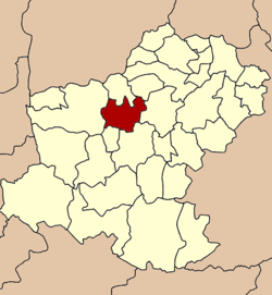
- Non Thai District
-
Non Thai
โนนไทย— Amphoe — Amphoe location in Nakhon Ratchasima Province Coordinates: 15°11′54″N 102°4′10″E / 15.19833°N 102.06944°ECoordinates: 15°11′54″N 102°4′10″E / 15.19833°N 102.06944°E Country  Thailand
Province Nakhon Ratchasima Seat Non Thai Tambon Muban Amphoe established Area - Total 542.0 km2 (209.3 sq mi) Population (2008) - Total 74,911 - Density 138.2/km2 (357.9/sq mi) Time zone THA (UTC+7) Postal code 30220 Geocode 3009 Non Thai (Thai: โนนไทย) is a district (amphoe) of Nakhon Ratchasima Province, northeastern Thailand.
Contents
History
Originally, the area was Khwaeng San Thia (แขวงสันเทียะ). San Thia is Khmer language, meaning a place to fulfill salt. The name refers to the tradition of salt manufacturing in that area.
In 1900, Khwaeng San Thia was changed to an Amphoe and renamed to Non Lao. However already in the following year it was named back to San Thia. In 1919, the district name was changed to be Non Lao again.[1] Finally in the phase of Thai nationalism under Field Marshal Plaek Phibunsongkhram, the district name was changed to be Non Thai in 1939[2] to remove the reference to the Lao population in the name.
Geography
Neighboring districts are (from the north clockwise) Phra Thong Kham, Kham Sakaesaeng, Non Sung, Mueang Nakhon Ratchasima, Kham Thale So and Dan Khun Thot.
Administration
The district in subdivided into 10 subdistricts (tambon), which are further subdivided into 131 villages (muban). There are three subdistrict municipalities (thesaban tambon) - Non Thai covering part of tambon Non Thai, Khok Sawai covering part of tambon Sai O. The whole tambon Banlang is also a subdistrict municipality. The non-municipal parts for each of the other 9 tambon is administrative by a Tambon administrative organization (TAO).
No. Name Thai Inh. 1. Non Thai โนนไทย 13,051 2. Dan Chak ด่านจาก 8,862 3. Kampang กำปัง 9,500 4. Samrong สำโรง 6,907 5. Khang Phlu ค้างพลู 5,439 6. Ban Wang บ้านวัง 4,841 7. Banlang บัลลังก์ 8,648 8. Sai O สายออ 7,544 9. Thanon Pho ถนนโพธิ์ 4,067 14. Makha มะค่า 6,052 Missing numbers are tambon which now form Phra Thong Kham district.
References
- ^ "ประกาศกระทรวงมหาดไทย เรื่อง เปลี่ยนชื่ออำเภอ" (in Thai). Royal Gazette 34 (0 ก): 40–68. 1917-04-29. http://www.ratchakitcha.soc.go.th/DATA/PDF/2460/A/40.PDF.
- ^ "พระราชกฤษฎีกาเปลี่ยนนามอำเภอ กิ่งอำเภอและตำบลบางแห่ง พุทธศักราช ๒๔๘๒" (in Thai). Royal Gazette 56 (0 ก): 877–882. 1939-09-25. http://www.ratchakitcha.soc.go.th/DATA/PDF/2482/A/877.PDF.
External links
- amphoe.com (Thai)
Mueang Nakhon Ratchasima · Khon Buri · Soeng Sang · Khong · Ban Lueam · Chakkarat · Chok Chai · Dan Khun Thot · Non Thai · Non Sung · Kham Sakaesaeng · Bua Yai · Prathai · Pak Thong Chai · Phimai · Huai Thalaeng · Chum Phuang · Sung Noen · Kham Thale So · Sikhio · Pak Chong · Nong Bun Mak · Kaeng Sanam Nang · Non Daeng · Wang Nam Khiao · Thepharak · Mueang Yang · Phra Thong Kham · Lam Thamenchai · Bua Lai · Sida · Chaloem Phra Kiat
Categories:- Amphoe of Nakhon Ratchasima
- Isan geography stubs
Wikimedia Foundation. 2010.

