- No Man's Heath, Warwickshire
-
Coordinates: 52°40′41″N 1°34′30″W / 52.678°N 1.575°W
No Mans Heath 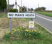
 No Mans Heath
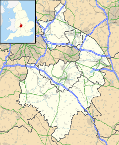
No Mans Heath shown within WarwickshireOS grid reference SK288090 District North Warwickshire Shire county Warwickshire Region West Midlands Country England Sovereign state United Kingdom Post town TAMWORTH Postcode district B79 Police Warwickshire Fire Warwickshire Ambulance West Midlands EU Parliament West Midlands List of places: UK • England • Warwickshire No Man's Heath (grid reference SK290090) is an area six miles north-east of Tamworth, Staffordshire. Its name indicates that it is on high heathland near the borders of four English counties: Derbyshire, Leicestershire, Warwickshire and Staffordshire. The place is probably a highpoint on an ancient road, either Roman or Mercian.[citation needed] Nearby in the late 19th century were Netherseal Colliery and Netherseal Hall.
Today a small village exists there, also called No Man's Heath. The county boundary which used to divide the village between Leicester and Warwickshire has been re-drawn to place the whole village in Warwickshire.[1] The village only indian restaurant is appropriately called The Four Counties Spice, this used to be the village only public house that was appropriately called The Four Counties Inn.
Leicestershire, Warwickshire, and Staffordshire meet about half a mile (800 m) northwest of the village and Derbyshire, Leicestershire, and Staffordshire meet a further half mile northwest. There is an ancient (probably Mercian) stone, divided into four parts, which may mark the point where the four counties met before boundary adjustments.
See also
- Four Corners Monument, a definite four states point in the USA.
- No Man's Heath, Cheshire, which probably takes its name from spanning four civil parishes.
References
External links
- The village should be shown on all of the four maps offered by old-maps.co.uk. But in fact it only appears on their set for Derbyshire.
- BBC Staffordshire article about the pub
Categories:- Geography of Leicestershire
- Villages in Warwickshire


Wikimedia Foundation. 2010.