- National Register of Historic Places listings in Southeast Denver, Colorado
-
This is a list of the National Register of Historic Places listings in Southeast Denver, Colorado.
This is intended to be a complete list of the properties and districts on the National Register of Historic Places in southeastern Denver, Colorado, United States. Southeast Denver is defined as being all of the city east of the South Platte River and south of Sixth Avenue. The locations of National Register properties and districts may be seen in a Google map.[1]
There are 288 properties and districts listed on the National Register in Denver. Southeast Denver includes 42 of these properties and districts, including 3 that extend into other regions; the city's remaining properties and districts are listed elsewhere.
-
- This National Park Service list is complete through NPS recent listings posted November 10, 2011.[2]
Current listings
[3] Landmark name[4] Image Date listed Location Neighborhood Summary 1 Alamo Placita Park 
September 17, 1986 Roughly bounded by Speer Boulevard, 1st Ave., and Clarkson St.
39°43′14″N 104°58′30″W / 39.72056°N 104.975°WSpeer 2 Belcaro 
February 10, 1975 3400 Belcaro Dr.
39°42′4″N 104°56′49″W / 39.70111°N 104.94694°WBelcaro 3 Buchtel Bungalow 
November 3, 1988 2100 S. Columbine St.
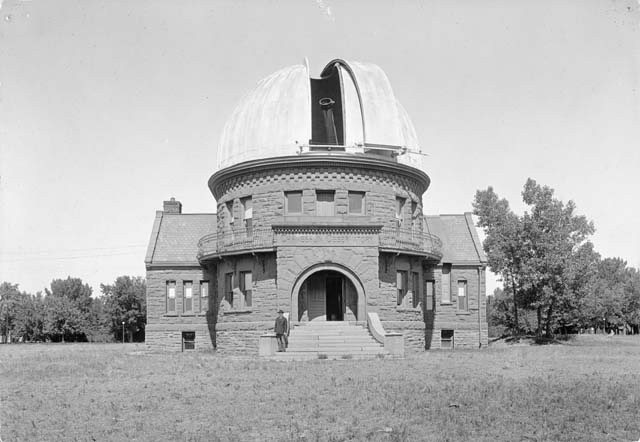
39°40′42″N 104°57′20″W / 39.67833°N 104.95556°WUniversity Park 4 Chamberlin Observatory 
March 27, 1980 2930 E. Warren Ave.
39°40′32″N 104°57′9″W / 39.67556°N 104.9525°WUniversity Park 5 Chapel No. 1 
May 6, 1982 Reeves St. on Lowry Air Force Base39°43′16″N 104°54′4″W / 39.72111°N 104.90111°W Lowry Field 6 Cheesman Park Duplex 
May 5, 1983 1372 S. Pennsylvania St.
39°41′32″N 104°58′50″W / 39.69222°N 104.98056°WPlatt Park 7 Cheesman Park Esplanade 
September 17, 1986 Roughly bounded by 8th Ave., High St., the 7th Ave. Parkway, and Williams St.
39°43′42″N 104°57′53″W / 39.72833°N 104.96472°WCountry Club 8 Clermont Street Parkway 
September 17, 1986 Clermont St. Parkway from E. 3rd Ave. to E. 6th Ave.
39°43′23″N 104°56′3″W / 39.72306°N 104.93417°WHilltop 9 Country Club Historic District 
July 10, 1979 Roughly bounded by 1st and 4th Aves., Race and Downing Sts.; also between Downing and University, E. 4th Ave. and north of Alameda Ave.
39°43′13″N 104°58′5″W / 39.72028°N 104.96806°WCountry Club Second set of addresses represents a boundary increase 10 Cranmer House 
July 27, 2005 200 Cherry St.
39°43′11″N 104°55′59″W / 39.71972°N 104.93306°WHilltop 11 Cranmer Park 
September 17, 1986 Roughly bounded by E. 3rd Ave., Cherry St., E. 1st Ave., and Bellaire St.
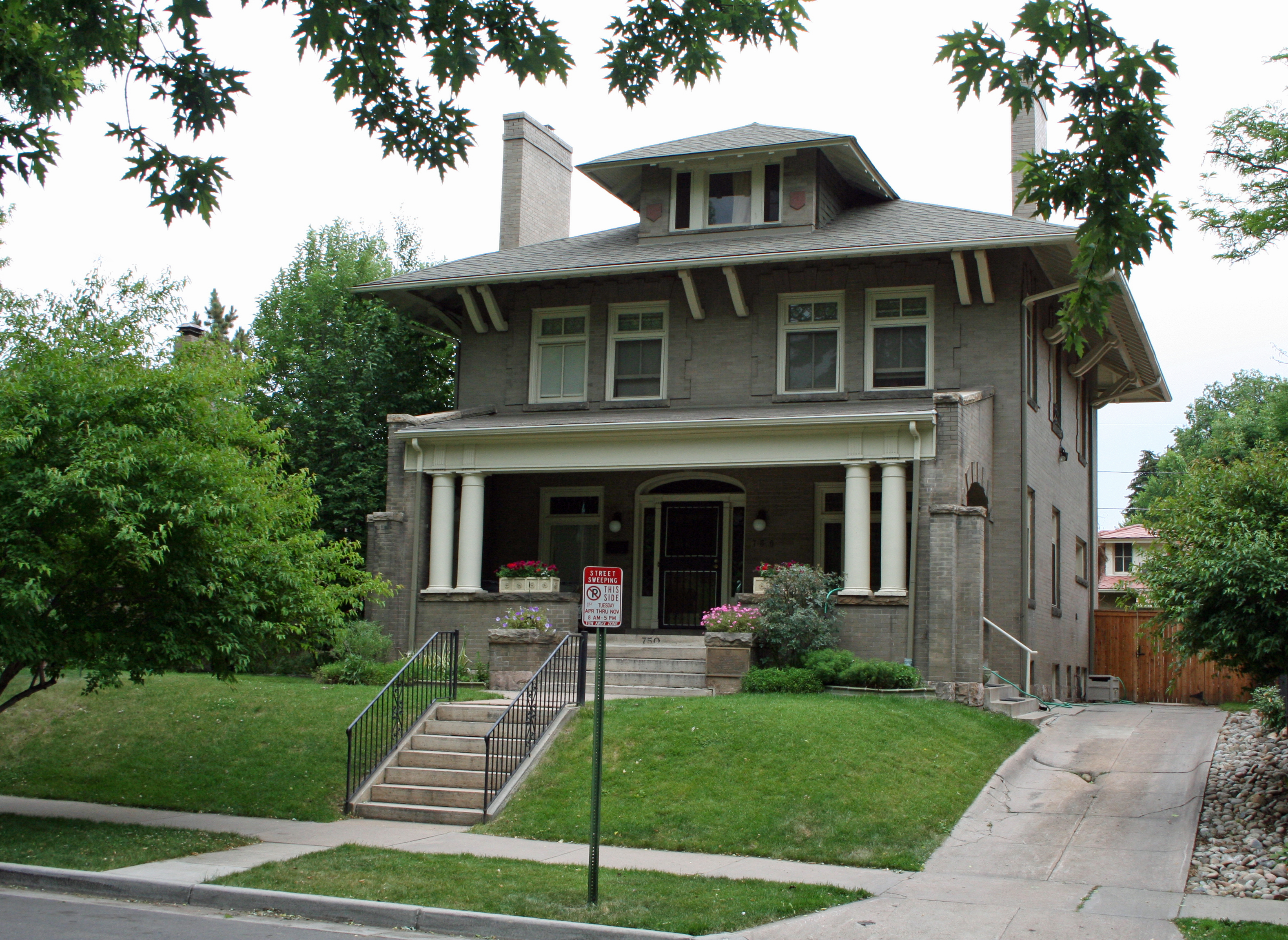
39°43′10″N 104°56′6″W / 39.71944°N 104.935°WHilltop 12 John and Elivera Doud House 
September 28, 2005 750 Lafayette St.
39°43′49″N 104°58′13″W / 39.73028°N 104.97028°WCountry Club 13 Downing Street Parkway 
September 17, 1986 Downing St. Parkway from E. Bayaud Ave. to E. 3rd Ave.
39°43′3″N 104°58′20″W / 39.7175°N 104.97222°WSpeer 14 East Fourth Avenue Parkway 
September 17, 1986 E. 4th Ave. Parkway from Gilpin St. to Williams St.
39°43′19″N 104°57′57″W / 39.72194°N 104.96583°WCountry Club 15 East Sixth Avenue Parkway 
September 17, 1986 E. 6th Ave. Parkway from Colorado Boulevard to Quebec St.
39°43′7″N 104°55′38″W / 39.71861°N 104.92722°WHilltop Extends into Hale and Montclair in Northeast Denver 16 Evans Memorial Chapel 
December 27, 1974 University of Denver campus
39°40′36″N 104°57′46″W / 39.67667°N 104.96278°WUniversity 17 Eugene Field House 
November 1, 1974 715 S. Franklin St.
39°42′13″N 104°58′7″W / 39.70361°N 104.96861°WWashington Park 18 Fitzroy Place 
February 20, 1975 2160 S. Cook St.
39°40′39″N 104°56′47″W / 39.6775°N 104.94639°WUniversity Park 19 Four-Mile House 
December 3, 1969 715 S. Forest St.
39°42′11″N 104°55′36″W / 39.70306°N 104.92667°WWashington Virginia Vale 20 Hungarian Freedom Park 
September 17, 1986 Roughly bounded by Speer Boulevard, 1st Ave., and Clarkson St.
39°43′7″N 104°58′32″W / 39.71861°N 104.97556°WSpeer 21 Iliff Hall 
April 19, 2006 2201 S. University Boulevard
39°40′34″N 104°57′37″W / 39.67611°N 104.96028°WUniversity At Iliff School of Theology 22 Lloyd M. Joshel House 
December 28, 1995 220 S. Dahlia St.
39°42′45″N 104°55′51″W / 39.7125°N 104.93083°WHilltop 23 Kerr House 
February 28, 2002 1900 E. 7th Ave. Parkway
39°43′37″N 104°57′50″W / 39.72694°N 104.96389°WCountry Club 24 Kohn House 
July 27, 2005 770 High St.
39°43′43″N 104°57′50″W / 39.72861°N 104.96389°WCountry Club 25 Leeman Auto Company Building 
September 27, 2001 550 Broadway
39°43′31″N 104°59′11″W / 39.72528°N 104.98639°WSpeer 26 Lowry Field Brick Barracks 
September 3, 1998 200 N. Rampart Way
39°43′19″N 104°53′55″W / 39.72194°N 104.89861°WLowry Field 27 Monaco Street Parkway 
September 17, 1986 Monaco St. Parkway from E. 1st Ave. to Montview Boulevard
39°43′58″N 104°54′43″W / 39.73278°N 104.91194°WHilltop Extends into Montclair and South Park Hill in Northeast Denver 28 Nordlund House 
February 12, 1998 330 Birch St.
39°43′18″N 104°56′8″W / 39.72167°N 104.93556°WHilltop 29 Norman Apartments 
December 22, 1983 99 S. Downing St.
39°42′54″N 104°58′24″W / 39.715°N 104.97333°WSpeer 30 Photography and Armament School Buildings, Lowry Air Force Base 
April 2, 2002 125 and 130 Rampart Way and 7600 E. 1st Place
39°43′13″N 104°53′53″W / 39.72028°N 104.89806°WLowry Field 31 Henry Roth House 
September 30, 1997 5, 7, and 9 S. Fox St.
39°43′0″N 104°59′42″W / 39.716667°N 104.995°WBaker 32 Saint Thomas Theological Seminary 
July 27, 1989 1300 S. Steele
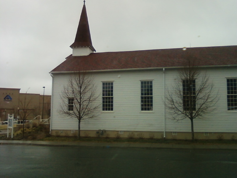
39°41′35″N 104°56′50″W / 39.69306°N 104.94722°WCory-Merrill 33 Sixth Avenue Community Church 
December 17, 2010 3250 E. Sixth Ave.
39°43′31″N 104°56′56″W / 39.72528°N 104.94889°WCherry Creek 34 Smith's Irrigation Ditch 
October 8, 1976 Washington Park
39°42′1″N 104°58′13″W / 39.70028°N 104.97028°WWashington Park 35 South Marion Street Parkway 
September 17, 1986 S. Marion St. Parkway from E. Virginia Ave. to E. Bayaud Ave. at Downing St.
39°42′42″N 104°58′19″W / 39.71167°N 104.97194°WWashington Park 36 South Side-Baker Historic District 
October 3, 1985 Roughly bounded by W. 5th Ave., Broadway, W. Alameda Ave., and W. Fox St.
39°43′5″N 104°59′26″W / 39.71806°N 104.99056°WBaker 37 Speer Boulevard 
September 17, 1986 Speer Boulevard from W. Colfax Ave. to Downing St.
39°43′42″N 104°59′9″W / 39.72833°N 104.98583°WSpeer Extends into Civic Center in Downtown Denver and Lincoln Park in Northeast Denver 38 Temple Emanuel 
May 19, 2003 51 Grape St.
39°43′0″N 104°55′30″W / 39.716667°N 104.925°WHilltop 39 University Boulevard 
September 17, 1986 University Boulevard from E. Iowa Ave. to E. Alameda Ave.
39°41′57″N 104°57′31″W / 39.69917°N 104.95861°WBelcaro, Cory-Merrill, and Washington Park 40 Washington Park 
September 17, 1986 Roughly bounded by E. Virginia Ave., S. Franklin St., E. Louisiana Ave., and S. Downing St.
39°42′0″N 104°58′13″W / 39.7°N 104.97028°WWashington Park Includes both the park and the neighborhood built around it 41 Weckbaugh House 
January 16, 1984 1701 E. Cedar Ave.
39°42′42″N 104°57′59″W / 39.71167°N 104.96639°WWashington Park 42 Williams Street Parkway 
September 17, 1986 Williams St. Parkway from E. 4th Ave. to E. 8th Ave.
39°43′45″N 104°57′54″W / 39.72917°N 104.965°WCountry Club See also
- List of National Historic Landmarks in Colorado
- National Register of Historic Places listings in Denver, Colorado
References
- ^ The latitude and longitude information provided in this table was derived originally from the National Register Information System, which has been found to be fairly accurate for about 99% of listings. For about 1% of NRIS original coordinates, experience has shown that one or both coordinates are typos or otherwise extremely far off; some corrections may have been made. A more subtle problem causes many locations to be off by up to 150 yards, depending on location in the country: most NRIS coordinates were derived from tracing out latitude and longitudes off of USGS topographical quadrant maps created under North American Datum of 1927, which differs from the current, highly accurate GPS system used by Google maps. Chicago is about right, but NRIS longitudes in Washington are higher by about 4.5 seconds, and are lower by about 2.0 seconds in Maine. Latitudes differ by about 1.0 second in Florida. Some locations in this table may have been corrected to current GPS standards.
- ^ "National Register of Historic Places: Weekly List Actions". National Park Service, United States Department of the Interior. Retrieved on November 10, 2011.
- ^ Numbers represent an ordering by significant words. Various colorings, defined here, differentiate National Historic Landmark sites and National Register of Historic Places Districts from other NRHP buildings, structures, sites or objects.
- ^ "National Register Information System". National Register of Historic Places. National Park Service. 2008-04-24. http://nrhp.focus.nps.gov/natreg/docs/All_Data.html.
Categories:- Buildings and structures in Denver, Colorado
- National Register of Historic Places in Denver, Colorado
-


Wikimedia Foundation. 2010.