- Nam Som District
-
Nam Som
น้ำโสม— Amphoe — Amphoe location in Udon Thani Province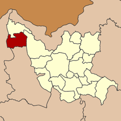
Coordinates: 17°46′14″N 102°11′23″E / 17.77056°N 102.18972°ECoordinates: 17°46′14″N 102°11′23″E / 17.77056°N 102.18972°E Country  Thailand
Province Udon Thani Seat Ban Yuak Tambon Muban Amphoe established Area - Total 742.129 km2 (286.5 sq mi) Population (2005) - Total 55,622 - Density 74.9/km2 (194/sq mi) Time zone THA (UTC+7) Postal code 41210 Geocode 4118 Nam Som (Thai: น้ำโสม) is a district (Amphoe) in the northwestern part of Udon Thani Province, northeastern Thailand.
Contents
Geography
Neighboring districts are (from the north clockwise) Na Yung, Ban Phue of Udon Thani Province, Suwannakhuha of Nongbua Lamphu Province and Pak Chom of Loei Province.
History
The minor district (King Amphoe) was created on May 12 1969, when the two tambon Nam Som and Na Yung were split off from Ban Phue district.[1] The third tambon Nong Waeng was added on July 4 1969.[2] The minor district was upgraded to a full district on April 1 1974.[3]
Administration
The district is subdivided into 7 subdistricts (tambon), which are further subdivided into 80 villages (muban). There are two townships (thesaban tambon) - Na Ngua covers parts of tambon Na Ngua and Si Samran; Nam Som cover parts of tambon Nam Som and also Si Samran. There are further 7 Tambon administrative organizations (TAO).
No. Name Thai name Villages Inh. 1. Na Ngua นางัว 10 8,848 2. Nam Som น้ำโสม 16 10,860 5. Nong Waeng หนองแวง 13 8,061 6. Ban Yuak บ้านหยวก 15 9,307 7. Som Yiam โสมเยี่ยม 6 4,215 10. Si Samran ศรีสำราญ 12 8,567 12. Samakkhi สามัคคี 8 5,764 Missing numbers are tambon which now form Na Yung district.
References
- ^ "ประกาศกระทรวงมหาดไทย เรื่อง แบ่งท้องที่ตั้งเป็นกิ่งอำเภอ" (in Thai). Royal Gazette 86 (44 ง): 1728. May 20 1969. http://www.ratchakitcha.soc.go.th/DATA/PDF/2512/D/044/1728.PDF.
- ^ "ประกาศกระทรวงมหาดไทย เรื่อง แก้ไขประกาศแบ่งท้องที่ตั้งเป็นกิ่งอำเภอ" (in Thai). Royal Gazette 86 (67 ง): 2277. July 22 1969. http://www.ratchakitcha.soc.go.th/DATA/PDF/2512/D/067/2277.PDF.
- ^ "พระราชกฤษฎีกาตั้งอำเภอเขาวง อำเภอเชียงม่วน อำเภอดอนตาล อำเภอชาติตระการ อำเภอภูเรือ อำเภอเคียนซา อำเภอน้ำโสม อำเภอหนองวัวซอ และอำเภอน้ำยืน พ.ศ. ๒๕๑๗" (in Thai). Royal Gazette 91 (54 ก special issue): 30–33. March 28 1974. http://www.ratchakitcha.soc.go.th/DATA/PDF/2517/A/054/30.PDF.
External links
Mueang Udon Thani · Kut Chap · Nong Wua So · Kumphawapi · Non Sa-at · Nong Han · Thung Fon · Chai Wan · Si That · Wang Sam Mo · Ban Dung · Ban Phue · Nam Som · Phen · Sang Khom · Nong Saeng · Na Yung · Phibun Rak · Ku Kaeo · Prachaksinlapakhom
Categories:- Amphoe of Udon Thani
- Isan geography stubs

Wikimedia Foundation. 2010.