- Murfreesboro Municipal Airport
-
Murfreesboro Municipal Airport 
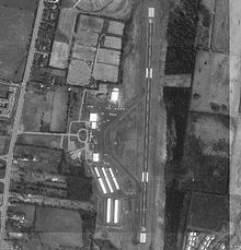
USGS image of Murfreesboro Municipal IATA: none – ICAO: KMBT – FAA LID: MBT Summary Airport type Public Owner/Operator City of Murfreesboro Location Murfreesboro, TN Elevation AMSL 614 ft / 187 m Coordinates 35°52.65′N 86°22.65′W / 35.8775°N 86.3775°WCoordinates: 35°52.65′N 86°22.65′W / 35.8775°N 86.3775°W Website Runways Direction Length Surface ft m 18/36 3,898 1,188 Asphalt FAA Murfreesboro Municipal Airport (ICAO: KMBT, FAA LID: MBT) is about 2 nm north of the central business district of Murfreesboro, Tennessee, United States. It is also the home of the Middle Tennessee State University Aerospace aircraft and simulators. MTSU has 1- Boeing 727, 1- Diamond DA-20s, 17- Diamond DA-40s with the Garmin 1000 avionics suite, 2- Diamond DA-40s without the Garmin 1000 avionics suite, 3- Piper PA-28R Arrows, 2- Piper PA-44 Seminole, 3- Cessna 152s, 1- Piper Super Cub, 1- de Havilland Canada DHC-2 Beaver, 1-Beechcraft King Air 200, 1- Cessna T-41 and 1- Cessna 172RG.[1]
The airport has one runway (18-36), 3,898 ft long (1,188 m) by 100 ft wide (30 m).[2]
The Murfreesboro Municipal Airport is one of the only General Aviation Airports in the State of Tennessee that does not receive tax payer money. The money used to maintain the airport is entirely generated by leases and fuel sales.
In 2007 the airport won the Tennessee Airport of the Year award.
References
External links
- Resources for this airport:
- AirNav airport information for MBT
- FlightAware airport information and live flight tracker
- SkyVector aeronautical chart for MBT
Categories:- Murfreesboro, Tennessee
- Airports in Tennessee
- Buildings and structures in Rutherford County, Tennessee
- Southern United States airport stubs
- Tennessee geography stubs
- Resources for this airport:
Wikimedia Foundation. 2010.
