- Murchison River Gorge
-
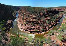 view of Murchison Gorge from the Z Bend lookout
Murchison River Gorge is a riverine gorge in Mid West Western Australia. Carved by the meandering lower reaches of the Murchison River, it is more than 80 kilometres long, and up to 129 metres deep. It begins about 13½ kilometres nort-northwest of Ajana, and extends to the mouth of the river at Kalbarri.
Widely considered a site of outstanding natural beauty, it is a major tourist attraction. Specific points of interest for tourists include the Z Bend lookout and The Loop walking trail.
It is also of immense interest to geologists, as it contains outstanding exposures of Tumblagooda sandstone, an Ordovician redbed deposit that contains fossils of eurypterids, representing some of the earlier fossil evidence of land animals. Fossilised eurypterid tracks are fairly common in the vicinity of the gorge, as are the tracks of outher arthropods, possibly trilobites.
The gorge is considered to be in excellent condition. Protection is afforded by the fact that it is almost entirely included within the boundaries of Kalbarri National Park, and also by its listing, since 1978, on Australia's Register of the National Estate.
References
- "Murchison River Gorge". Heritage Council of Western Australia Places Database. http://register.heritage.wa.gov.au/viewplace.html?place_seq=25275. Retrieved 2009-01-29.
- "Murchison River Gorge, Ajana, WA, Australia (entry AHD19027)". Australian Heritage Database. Department of Sustainability, Environment, Water, Population and Communities. http://www.environment.gov.au/cgi-bin/ahdb/search.pl?mode=place_detail;place_id=19027. Retrieved 2009-01-29.
- Mory, A. J.; Hocking, R. M. (2008). Geology of the Kalbarri and Mingenew areas — A field guide. Geological Survey of Western Australia Record 2008/11. Department of Industry and Resources, Government of Western Australia. http://geodocs.doir.wa.gov.au/search.jsp?cabinetId=1101&Combined=N08S/4. Retrieved 2008-01-23.
Categories:- Canyons and gorges of Australia
- Geology of Western Australia
- Heritage places of Western Australia
- Mid West (Western Australia)
- Visitor attractions in Western Australia

Wikimedia Foundation. 2010.