- Murchison Falls National Park
-
Murchison Falls National Park Kabalega National Park IUCN Category II (National Park)Location of Murchison Falls National Park

Location Uganda Nearest city Masindi Coordinates 02°15′N 31°48′E / 2.25°N 31.8°ECoordinates: 02°15′N 31°48′E / 2.25°N 31.8°E Area 3,480 square kilometres (1,340 sq mi) Established 1952 Governing body Ugandan Wildlife Authority Murchison Falls National Park is a national park in Uganda. The park lies in north western Uganda, spreading inland from the shore of Lake Albert around the Victoria Nile. It is named for the Murchison Falls waterfall, itself named for a president of the Royal Geographical Society. The park is known for its wildlife which has partly recovered from a massacre by poachers and troops under Idi Amin. Together with the adjacent 748 square kilometres (289 sq mi) Bugungu Wildlife Reserve and the 720 square kilometres (280 sq mi) Karuma Wildlife Reserve, the park forms the Murchison Falls Conservation Area.[1]
The park is sometimes referred to as Kabarega National Park. Kabarega was the Omukama of the Kingdom of Bunyoro, around the end of the 19th century. He resisted colonization by the British, was arrested and was exiled by the British to the island nation of the Seychelles. Kabarega died in Jinja, in 1923 en-route to Bunyoro from exile.
Contents
Location
Murchison Falls National Park is located in Masindi District in western Uganda and in Amuru District in northern Uganda. The park is situated approximately 300 kilometres (190 mi), by road, northwest of Kampala, Uganda's capital city. The coordinates of the park are:02 15N, 31 48E (Latitude:2.2500; Longitude:31.8000).
Overview
Murchison Falls National Park is Uganda's largest national park. It measures approximately 3,840 square kilometres (1,480 sq mi). Together with the adjacent Bugungu Wildlife Reserve and the Karuma Wildlife Reserve, the park is part of the 5,308 square kilometres (2,049 sq mi) Murchison Falls Conservation Area (MFCA).[2] The park is bisected by the Victoria Nile from east to west for a distance of about 115 kilometres (71 mi). The park is the location of the famous Murchison Falls, where the waters of the majestic Nile River squeeze through a narrow gorge, only 7 metres (23 ft) wide, before plunging 43 metres (141 ft) below. Also in the park, adjacent to the Masindi-Gulu Highway, are the Karuma Falls, the proposed location of the 700 MW Karuma Power Station, Uganda's largest hydropower station, expected to come online sometime around 2016.[3]
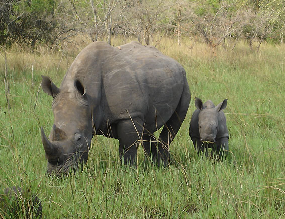
Murchison is Uganda's only National Park which has all "big five". Buffalos, elephants, lions, leopards are best to be seen in the northern part (above the Nile). Rhinos were sadly extinguished but are now being bred again in the rhino sanctuary south of the park; 40 to 50 rhinos are planned to be released into the wild in approx. 30 years (by 2040).
Gallery
-

Herd of buffalos
-
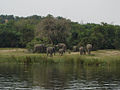
Elephants
-

Lion
-

White Rhinoceros (in rhino sanctuary south of the park)
-

Giraffe
-
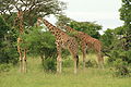
Giraffes
Fauna
The park is home to the large African wild animals including:
- Elephant
- Water buffalo
- Lion
- Leopard
- Hippopotamus
- Giraffes
- Crocodile
- Antelope
- Uganda Kob
- Hartebeest
- Oribi
- Other animals
The Nile River, within the park, is host to a variety of waterbirds, including the rare shoe-bill stork.[4]
See also
- List of national parks of Uganda
- Murchison Falls
- Kabalega
- Victoria Nile
- Paraa
- Uganda Wildlife Authority
- Masindi
References
External links
- Overview at Uganda Wildlife Authority
- Profile at Traveluganda.co.ug
- Profile at Safari-Uganda.com
- Website Devoted to the National Park
- YouTube video of Park near Paraa
National parks of Uganda Bwindi Impenetrable · Kibale · Kidepo Valley · Lake Mburo · Mgahinga Gorilla · Mount Elgon · Murchison Falls · Queen Elizabeth · Rwenzori Mountains · Semuliki
Categories:- IUCN Category II
- National parks of Uganda
- Masindi District
- Amuru District
-


Wikimedia Foundation. 2010.