- Aguascalientes Municipality
-
Aguascalientes — Municipality — 
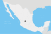
Coat of armsMotto: Virtus in Aquis, Fidelitas in Pectoribus Location of Aguascalientes in Aguascalientes.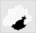
Coordinates: 21°53′N 102°18′W / 21.883°N 102.3°WCoordinates: 21°53′N 102°18′W / 21.883°N 102.3°W Country Mexico State Aguascalientes Municipal seat Aguascalientes Largest city Aguascalientes Government – Municipal president Martín Orozco Sandoval (  PAN)
PAN)Area – Total 1,178.85 km2 (455.2 sq mi) Population (2010) – Total 797,010 – Density 676.1/km2 (1,751.1/sq mi) Data source: INEGI Time zone CST (UTC-6) – Summer (DST) CDT (UTC-5) INEGI code 001 Website (Spanish) Municipio Virtual de Aguascalientes Source: Enciclopedia de los Municipios de México Aguascalientes is a municipality of the Mexican state of Aguascalientes. Its municipal seat is the city of Aguascalientes, which is also the state capital. As of 2010, its population was 797,010, most of whom lived in the city of Aguascalientes.[1]
Geography
Aguascalientes is in the south of the valley that divides the state in two and borders the municipalities of El Llano, Jesús María, Calvillo, Asientos, and San Francisco de los Romo in the state, as well as the state of Jalisco to the south. Its area is 1,169 km².[2]
References
- ^ (Spanish) Data, 2010 census, INEGI. Accessed on April 9, 2011.
- ^ (Spanish) Aguascalientes, Enciclopedia de los Municipios de México, Instituto Nacional Para el Federalismo y el Desarrollo Municipal, SEGOB. Accessed on line November 23, 2007.
Municipalities
and
(municipal seats)Aguascalientes (Aguascalientes) · Asientos (Asientos) · Calvillo (Calvillo) · Cosío (Cosío) · Jesús María (Jesús María) · El Llano (Palo Alto) · Pabellón de Arteaga (Pabellón de Arteaga) · Rincón de Romos (Rincón de Romos) · San Francisco de los Romo (San Francisco de los Romo) · San José de Gracia (San José de Gracia) · Tepezalá (Tepezalá)
 Categories:
- Municipalities of Aguascalientes
- Mexico geography stubs


Wikimedia Foundation. 2010.