- Rymill Park
-
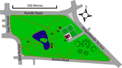
Rymill Park, also known as Park 14 or Mullawirraburka in Kaurna, is a park located in the East Parklands of the South Australian capital of Adelaide. It is bordered by East and Dequetteville Terraces, and Rundle and Bartels Roads. It is in close proximity to the Adelaide Botanic Garden, Hutt Street and Victoria Park.
The park occupies 14.5 hectares (36 acres) and is named after Sir Arthur Rymill, Lord Mayor of Adelaide from 1950 to 1954 and council member for 23 years. The lake and rose gardens were created in the 1960s by excavating what was then the Bartels Road rubbish tip.[1] It features a lake with rowboats, rose gardens, playgrounds, and a kiosk and barbecue facilities.
The park is a site for several major events including Carnevale in Adelaide, the Adelaide International Horse Trials and some events in the Adelaide Fringe and Feast festivals.
After being drained in November 2007, to make repairs addressing the leaking of 200,000 litres (53,000 US gal) per week, the lake was refilled in September 2008.[2]
References
- ^ Adelaide city council information sign in the park
- ^ "City lake refilled after repair job". ABC News. http://www.abc.net.au/news/stories/2008/09/12/2362565.htm.
External links
Squares Victoria Square | Light Square | Hindmarsh Square | Hurtle Square | Whitmore Square | Wellington Square
Parklands (1) Adelaide Golf Links | (2) Adelaide Aquatic Centre | (3) | (4) | (5) | (6) | (7) | (8) | (9) | (10) Park 10 | (11) Botanic Garden, Botanic Park, Zoo, Wine Centre, RAH, IMVS, University of Adelaide, UniSA | (12) University of Adelaide, UniSA, Art Gallery, Museum, State Library, War Memorial, Government House, Torrens Parade Ground, Boer War Memorial, Jubilee 150 Walkway, University Oval | (13) Rundle Park | (14) Rymill Park | (15) | (16) Victoria Park | (17) | (18) Himeji Gardens | (19) | (20) | (21) Veale Gardens | (22) | (23) West Terrace Cemetery | (24) Adelaide High School | (25) | (26) Adelaide Oval, Memorial Drive, St Peter's Cathedral, Light's Vision, Parliament House, Old Parliament House, Adelaide Railway Station, Convention Centre, Festival Centre, Elder Park | (27) Torrens Weir, Dame Roma Mitchell Gardens, Old Adelaide Gaol, Bonython Park, City Sk8 Park | (28) | (29) Brougham Gardens | Linear Park
Coordinates: 34°55′25″S 138°36′51″E / 34.9236°S 138.6141°E
Categories:- Parks in Adelaide
Wikimedia Foundation. 2010.


