- Muysky District
-
Muysky District (English)
Муйский район (Russian)
Муяын аймаг (Buryat)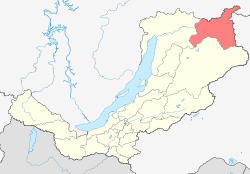
Location of Muysky District on the map of the Buryat RepublicAdministrative status (as of 2010) Country Russia Federal subject Republic of Buryatia[1] Administrative center urban-type settlement of Taksimo[1] Statistics Area 25,164.1 km2 (9,715.9 sq mi)[2] Population (2010 Census,
preliminary)13,166 inhabitants[3] Population (2002 Census) 16,641 inhabitants[4] - Urban population 90.3% - Rural population 9.7% Density 1 /km2 (2.6 /sq mi)[5] Time zone IRKST (UTC+09:00)[6] Established 1989[2] Muysky District (Russian: Муйский райо́н; Buryat: Муяын аймаг) is an administrative and municipal district (raion), one of the twenty-one in the Republic of Buryatia, Russia. The area of the district is 25,164.1 square kilometers (9,715.9 sq mi).[2] Its administrative center is the urban locality (an urban-type settlement) of Taksimo.[1] District's population: 13,166 (2010 Census preliminary results);[3] 16,641 (2002 Census).[7] Population of Taksimo accounts for 72.7% of the district's population.[3]
References
Notes
- ^ a b c Resolution #431, Part II
- ^ a b c Official website of the Republic of Buryatia. Information about Muysky District (Russian)
- ^ a b c Федеральная служба государственной статистики (Federal State Statistics Service) (2011). "Предварительные итоги Всероссийской переписи населения 2010 года (Preliminary results of the 2010 All-Russian Population Census)" (in Russian). Всероссийская перепись населения 2010 года (All-Russia Population Census of 2010). Federal State Statistics Service. http://www.perepis-2010.ru/results_of_the_census/results-inform.php. Retrieved 2011-04-25.
- ^ Федеральная служба государственной статистики (Federal State Statistics Service) (2004-05-21). "Численность населения России, субъектов Российской Федерации в составе федеральных округов, районов, городских поселений, сельских населённых пунктов – районных центров и сельских населённых пунктов с населением 3 тысячи и более человек (Population of Russia, its federal districts, federal subjects, districts, urban localities, rural localities—administrative centers, and rural localities with population of over 3,000)" (in Russian). Всероссийская перепись населения 2002 года (All-Russia Population Census of 2002). Federal State Statistics Service. http://www.perepis2002.ru/ct/doc/1_TOM_01_04.xls. Retrieved 2010-03-23.
- ^ The value of density was calculated automatically by dividing the 2010 Census population by the area specified in the infobox. Please note that this value may not be accurate as the area specified in the infobox does not necessarily correspond to the area of the entity proper or is reported for the same year as the population.
- ^ Правительство Российской Федерации. Постановление №725 от 31 августа 2011 г. «О составе территорий, образующих каждую часовую зону, и порядке исчисления времени в часовых зонах, а также о признании утратившими силу отдельных Постановлений Правительства Российской Федерации». Вступил в силу по истечении 7 дней после дня официального опубликования. Опубликован: "Российская Газета", №197, 6 сентября 2011 г. (Government of the Russian Federation. Resolution #725 of August 31, 2011 On the Composition of the Territories Included into Each Time Zone and on the Procedures of Timekeeping in the Time Zones, as Well as on Abrogation of Several Resolutions of the Government of the Russian Federation. Effective as of after 7 days following the day of the official publication).
- ^ Федеральная служба государственной статистики (Federal State Statistics Service) (2004-05-21). "Численность населения России, субъектов Российской Федерации в составе федеральных округов, районов, городских поселений, сельских населённых пунктов – районных центров и сельских населённых пунктов с населением 3 тысячи и более человек (Population of Russia, its federal districts, federal subjects, districts, urban localities, rural localities—administrative centers, and rural localities with population of over 3,000)" (in Russian). Всероссийская перепись населения 2002 года (All-Russia Population Census of 2002). Federal State Statistics Service. http://www.perepis2002.ru/ct/doc/1_TOM_01_04.xls. Retrieved 2010-03-23.
Sources
- Правительство Республики Бурятия. Постановление №431 от 18 ноября 2009 г. «О реестре административно-территориальных единиц и населённых пунктов Республики Бурятия», в ред. Постановления №210 от 27 мая 2010 г «О внесении изменений в некоторые Постановления Правительства Республики Бурятия по вопросам учёта и регистрации административно-территориальных единиц и населённых пунктов Республики Бурятия». Вступил в силу 18 ноября 2009 г. Опубликован: "Бурятия", №216, Официальный вестник №120, 21 ноября 2009 г. (Government of the Republic of Buryatia. Resolution #431 of November 18, 2009 On the Registry of the Administrative-Territorial Units and the Inhabited Localities of the Republic of Buryatia, as amended by the Resolution #210 of May 27, 2010 On Amending Several Resolutions of the Republic of Buryatia on the Enumeration and Registration of the Administrative-Territorial Units and the Inhabited Localities of the Republic of Buryatia. Effective as of November 18, 2009).
Administrative divisions of the Republic of Buryatia Capital: Ulan-Ude
Cities and towns 
Administrative districts Barguzinsky · Bauntovsky Evenkiysky · Bichursky · Dzhidinsky · Ivolginsky · Kabansky · Khorinsky · Kizhinginsky · Kurumkansky · Kyakhtinsky · Mukhorshibirsky · Muysky · Okinsky · Pribaykalsky · Selenginsky · Severo-Baykalsky · Tarbagataysky · Tunkinsky · Yeravninsky · Zaigrayevsky · ZakamenskyCategories:- Districts of the Republic of Buryatia
- States and territories established in 1989

Wikimedia Foundation. 2010.