- Mueang Rayong District
-
Mueang Rayong
เมืองระยอง— Amphoe — Amphoe location in Rayong Province
Coordinates: 12°40′6″N 101°16′30″E / 12.66833°N 101.275°ECoordinates: 12°40′6″N 101°16′30″E / 12.66833°N 101.275°E Country  Thailand
Province Rayong Seat Tha Pradu Area - Total 514.5 km2 (198.6 sq mi) Population (2008) - Total 229,657 - Density 410.3/km2 (1,062.7/sq mi) Time zone THA (UTC+7) Postal code 21000 Geocode 2101 Mueang Rayong (Thai: เมืองระยอง) is the capital district (amphoe mueang) of Rayong Province, eastern Thailand.
Contents
Geography
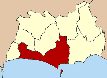
Neighboring districts are (from the west clockwise) Ban Chang, Nikhom Phatthana, Ban Khai, Wang Chan and Klaeng. To the south is the Gulf of Thailand.
Khao Laem Ya - Mu Ko Samet National Park is located in Mueang Rayong district.
History
Originally named Mueang, the district was renamed after its central subdistrict Tha Pradu (ท่าประดู่) in 1917. [1] In 1938 it was renamed to Mueang Rayong.[2]
Administration
The district is subdivided into 15 subdistricts (tambon), which are further subdivided into 86 villages (muban). Rayong is a city (thesaban nakhon) which covers the tambon Tha Pradu and Pak Nam and parts of tambon Choeng Noen and Noen Phra. The town (thesaban mueang) Map Ta Phut covers the whole tambon Map Ta Phut and Huai Pong, parts of Noen Phra and Thap Ma and also parts of tambon Mapkha of neighboring Nikhom Phatthana district. There are further two subdistrict municipalities (thesaban tambon) - Klaeng Kachet covers parts of the tambon Klaeng and Kachet, and Ban Phe parts of tambon Phe. The remaining areas of the subdistricts Noen Phra and Thap Ma as well as the whole Nam Khok are also each a subdistrict municipality. The other 8 subdistrict each have a Tambon administrative organization (TAO).
No. Name Thai Villages Inh.[3] 1. Tha Pradu ท่าประดู่ - 20,661 2. Choeng Noen เชิงเนิน 7 41,429 3. Taphong ตะพง 16 17,964 4. Pak Nam ปากน้ำ - 8,843 5. Phe เพ 7 18,129 6. Klaeng แกลง 7 11,094 7. Ban Laeng บ้านแลง 7 6,676 8. Na Ta Khwan นาตาขวัญ 6 6,293 9. Noen Phra เนินพระ 7 29,659 10. Kachet กะเฉด 10 7,056 11. Thap Ma ทับมา 8 18,187 12. Nam Khok น้ำคอก 4 4,450 13. Huai Pong ห้วยโป่ง 1 14,280 14. Map Ta Phut มาบตาพุด 1 19,746 15. Samnak Thong สำนักทอง 5 5,190 See also
References
- ^ "ประกาศกระทรวงมหาดไทย เรื่อง เปลี่ยนชื่ออำเภอ" (in Thai). Royal Gazette 34 (0 ก): 40–68. 1917-04-29. http://www.ratchakitcha.soc.go.th/DATA/PDF/2460/A/40.PDF.
- ^ "พระราชกฤษฎีกาเปลี่ยนนามจังหวัด และอำเภอบางแห่ง พุทธศักราช ๒๔๘๑" (in Thai). Royal Gazette 55 (0 ก): 658–666. 1938-11-14. http://www.ratchakitcha.soc.go.th/DATA/PDF/2481/A/658.PDF.
- ^ "Population statistics 2008". Department of Provincial Administration. http://www.dopa.go.th/xstat/p5121_01.html.
External links
- amphoe.com (thai)
Mueang Rayong · Ban Chang · Klaeng · Wang Chan · Ban Khai · Pluak Daeng · Khao Chamao · Nikhom Phatthana
Categories:- Amphoe of Rayong
- Eastern Thailand geography stubs
Wikimedia Foundation. 2010.