- Mueang Phetchaburi District
-
Mueang Phetchaburi
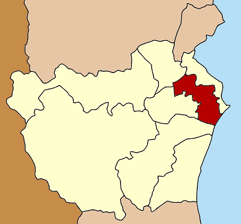
เมืองเพชรบุรี— Amphoe — Amphoe location in Phetchaburi Province
Coordinates: 13°6′43″N 99°56′38″E / 13.11194°N 99.94389°ECoordinates: 13°6′43″N 99°56′38″E / 13.11194°N 99.94389°E Country  Thailand
Province Phetchaburi Seat Tambon Muban Amphoe established Area – Total 283.9 km2 (109.6 sq mi) Population (2000) – Total 115,000 – Density 405.1/km2 (1,049.2/sq mi) Time zone THA (UTC+7) Postal code 76000 Geocode 7601 Mueang Phetchaburi (Thai: เมืองเพชรบุรี) is the capital district (Amphoe Mueang) of Phetchaburi Province, central Thailand.
History
The district was established around 1903. The government named it Khlong Krachaeng because its center was located in Tambon Khlong Krachaeng.
Geography
Neighboring districts are (from the northeast clockwise) Ban Laem, Khao Yoi, Ban Lat, Tha Yang of Phetchaburi Province and the Bay of Bangkok.
The important water resource is the Phetchaburi River.
Administration
The district is subdivided into 24 subdistricts (tambon), which are further subdivided into 184 villages (muban). There are three municipal areas within the district - the town (thesaban mueang) Phetchaburi covers the complete tambon Tha Rap and Khlong Krachaeng. Further there are two townships (thesaban tambon), Hat Chao Sam Ran covers the whole tambon Hat Chao Sam Ran, and Hua Saphan covers the whole Hua Saphan and Wang Tako. The non-municipal area is administrated by 18 Tambon administrative organizations (TAO).
1. Tha Rap ท่าราบ 2. Khlong Krachaeng คลองกระแชง 3. Bang Chan บางจาน 4. Na Phan Sam นาพันสาม 5. Thong Chai ธงชัย 6. Ban Kum บ้านกุ่ม 7. Nong Sano หนองโสน 8. Rai Som ไร่ส้ม 9. Wiang Khoi เวียงคอย 10. Bang Chak บางจาก 11. Ban Mo บ้านหม้อ 12. Ton Mamuang ต้นมะม่วง 13. Chong Sakae ช่องสะแก 14. Na Wung นาวุ้ง 15. Sam Marong สำมะโรง 16. Pho Phra โพพระ 17. Hat Chao Samran หาดเจ้าสำราญ 18. Hua Saphan หัวสะพาน 19. Ton Maphrao ต้นมะพร้าว 20. Wang Tako วังตะโก 21. Pho Rai Wan โพไร่หวาน 22. Don Yang ดอนยาง 23. Nong Khanan หนองขนาน 24. Nong Phlap หนองพลับ Mueang Phetchaburi · Khao Yoi · Nong Ya Plong · Cha-am · Tha Yang · Ban Lat · Ban Laem · Kaeng Krachan
Categories:- Amphoe of Phetchaburi
- Central Thailand geography stubs
Wikimedia Foundation. 2010.