- Mueang Lamphun District
-
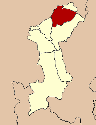
Mueang Lamphun
เมืองลำพูน— Amphoe — Amphoe location in Lamphun Province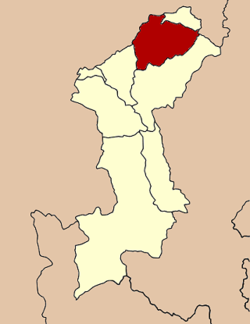
Coordinates: 18°34′41″N 99°1′4″E / 18.57806°N 99.01778°ECoordinates: 18°34′41″N 99°1′4″E / 18.57806°N 99.01778°E Country  Thailand
Province Lamphun Seat Tambon Muban Amphoe established Area - Total 479.8 km2 (185.3 sq mi) Population (2005) - Total 140,486 - Density 292.8/km2 (758.3/sq mi) Time zone THA (UTC+7) Postal code 51000 Geocode 5101 Mueang Lamphun (Thai: เมืองลำพูน; IPA: [mɯ̄aŋ lām.pʰūːn]) is the capital district (amphoe mueang) of Lamphun Province, northern Thailand.
Contents
Geography
Neighboring districts are (from the south clockwise) Mae Tha and Pa Sang of Lamphun Province, San Pa Tong, Hang Dong, Saraphi of Chiang Mai Province, Ban Thi of Lamphun and Mae On of Chiang Mai again.
The main river of the district is the Ping River.
Administration
The district is subdivided into 17 subdistricts (tambon), which are further subdivided into 158 villages (muban). The town (thesaban mueang) Lamphun covers the whole tambon Nai Mueang. There are three more subdistrict municipalities (thesaban tambon) - Umong and Rim Ping cover the complete same-named tambon, and Ban Paen parts of tambon Ban Paen and Nong Nam. There are further 12 Tambon administrative organizations (TAO).
No. Name Thai name Villages Inh. 1. Nai Mueang ในเมือง - 14,068 2. Mueang Nga เหมืองง่า 10 14,067 3. Umong อุโมงค์ 11 13,558 4. Nong Chang Khuen หนองช้างคืน 6 3,925 5. Pratu Pa ประตูป่า 9 5,832 6. Rim Ping ริมปิง 10 7,088 7. Ton Thong ต้นธง 11 10,982 8. Ban Paen บ้านแป้น 9 6,445 9. Mueang Chi เหมืองจี้ 14 9,298 10. Pa Sak ป่าสัก 18 11,797 11. Wiang Yong เวียงยอง 8 6,096 12. Ban Klang บ้านกลาง 12 8,195 13. Makhuea Chae มะเขือแจ้ 20 15,249 16. Si Bua Ban ศรีบัวบาน 12 9,010 17. Nong Nam หนองหนาม 8 4,876 See also
External links
- amphoe.com (Thai)
Mueang Lamphun · Mae Tha · Ban Hong · Li · Thung Hua Chang · Pa Sang · Ban Thi · Wiang Nong Long
Categories:- Amphoe of Lamphun
- Northern Thailand geography stubs
Wikimedia Foundation. 2010.