- Otake (Nakanoshima)
-
Otake 御岳 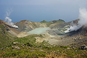
Inside the crater. (May 2007)Elevation 979 m (3,212 ft) Listing List of mountains and hills of Japan by height
List of volcanoes in JapanTranslation honorable mountain (Japanese) Location Location Nakanoshima, Japan Coordinates 29°51′33″N 129°51′25″E / 29.85917°N 129.85694°ECoordinates: 29°51′33″N 129°51′25″E / 29.85917°N 129.85694°E Topo map Geographical Survey Institute, 25000:1 中之島, 50000:1 中之島 Geology Type stratovolcano Age of rock Late Pleistocene-Holocene Volcanic arc/belt Ryukyu arc Last eruption October 1944 Otake (御岳 O-take) is a stratovolcano[1] in the Tokara Islands of Japan. It is the largest mountain on Nakanoshima, which is part of Toshima in Kagoshima District of Kagoshima Prefecture. Being the largest mountain on a small island, it is also referred to as Nakanoshima.
The mountain is an andesitic volcano. The volcano had a minor mud eruption in January 1914. In October 1949 the summit crater produced an ash cloud.[1][2] The rock of the mountain is non-alkali mafic rock produced in the last 18,000 years.[3]
Sulphur mining took place on the southeast flank until 1944. During the rainy season, the summit crater fills with water.[2]
References
- ^ a b "NAKANO-SHIMA". Quaternary Volcanoes of Japan. Geographical Survey Institute, AIST. 2006. http://riodb02.ibase.aist.go.jp/strata/VOL_JP/EN/vol/7.htm. Retrieved 2009-04-24.
- ^ a b "Nakano-shima". Global Volcanism Program. Smithsonian National Museum of Natural History. http://www.volcano.si.edu/world/volcano.cfm?vnum=0802-04=. Retrieved 2009-04-24.
- ^ "Kyushu". Seamless Digital Geological Map of Japan. Geographical Survey of Japan, AIST. 2006. http://riodb02.ibase.aist.go.jp/db084/kihon/kyushu_e.xml. Retrieved 2009-04-24.

This Kagoshima Prefecture location article is a stub. You can help Wikipedia by expanding it.